Renedo de la Vega geodata
Renedo de la Vega (Castille and León) is a seat of a third-order administrative division; located in Spain in Europe/Madrid (GMT+2) time zone. With population of 256 people, there are 4710 cities with bigger population in this country. Compared to other cities in Spain, 86.2% of cities are located further ↓South; 68.7% of cities are located further →East and 77.6% of cities have lower elevation than Renedo de la Vega. Note1
Administrative division(s):
- Level 1: Castille and León
- Level 2: Provincia de Palencia
- Level 3: Renedo de la Vega


Renedo de la Vega GPS coordinates[2]
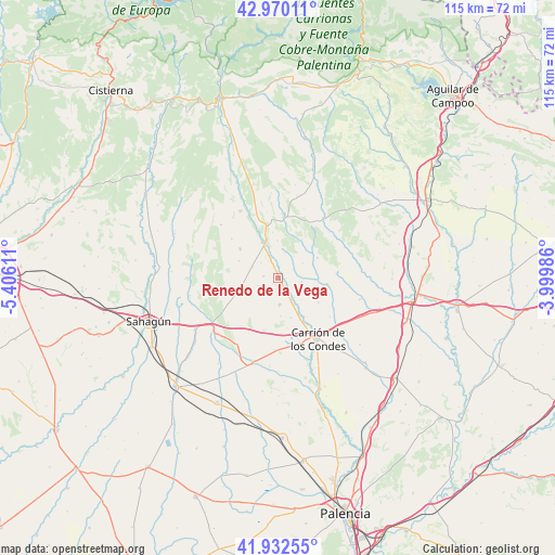
42° 27' 12.528" North, 4° 42' 10.728" West
| Map corner | latitude | longitude |
|---|---|---|
| Upper-left | 42.97011°, | -5.40611° |
| Center: | 42.45348°, | -4.70298° |
| Lower-right: | 41.93255°, | -3.99986° |
| Map W x H: | 115.4×115.4 km | = 71.7×71.7mi |
| max Lat: | 43.74134° ⇑13.8% North |
| Renedo de la Vega: | 42.45348° |
| min Lat: | ⇓86.2% South 27.64134° |
| min Long | Renedo de la Ve | max Long |
| -18.00367° | -4.70298° | 4.2899° |
| W 31.3%⇐ | ⇒68.7% E |
Elevation
Elevation of Renedo de la Vega is 875 m = 2871 ft, and this is 277 m = 909 ft above average elevation for this country.
| Max E: |
1682 m = 5518 ft | 22.4% |
| Renedo de la Vega | 875 m 2871 ft | |
| Avg. | 598 m = 1962 ft | |
Min E: |
0 m = 0 ft | 77.6% |
See also: Spain elevation on elevation.city.
Geographical zone
Renedo de la Vega is located in North temperate zone (between Tropic of Cancer and the Arctic Circle). Distance of this Northern Tropic circle is 2114.5 km =1313.9 mi to South.| Distance of | km | miles | from Renedo de la Vega |
|---|---|---|---|
| North Pole | 5286.7 | 3285 | to North |
| Arctic Circle | 2680.8 | 1665.8 | to North |
| Tropic Cancer | 2114.5 | 1313.9 | to South |
| Equator | 4720.4 | 2933.1 | to South |


Nearby cities:
15 places around Renedo de la Vega: (largest is in red/bold)
• Bustillo de la Vega
3.1 km =1.9 mi,  275°
275°
• Bustillo del Páramo de Carrión
11.3 km =7 mi,  195°
195°
• Calzada de los Molinos
14.6 km =9.1 mi,  163°
163°
• Carrión de los Condes
15 km =9.3 mi,  146°
146°
• Nogal de las Huertas
8.4 km =5.2 mi,  143°
143°
• Pedrosa de la Vega
4.8 km =3 mi,  311°
311°
• Quintanilla de Onsoña
3.7 km =2.3 mi,  61°
61°
• Saldaña
8 km =5 mi,  340°
340°
• San Mamés de Campos
15.7 km =9.8 mi,  134°
134°
• Santervás de la Vega
9.9 km =6.2 mi, 306°
• Villaluenga de la Vega
9.3 km =5.8 mi,  327°
327°
• Villamoronta
5.6 km =3.5 mi,  176°
176°
• Villarrabé
7.6 km =4.7 mi,  241°
241°
• Villasila de Valdavia
14.7 km =9.1 mi,  53°
53°
• Villaturde
8.8 km =5.5 mi, 162°
Sources, notices
• [Note1] Compared only with cities in Spain existing in our database
• [Src1] Map data: © OpenStreetMap contributors (CC-BY-SA)
• [Src2] Other city data from geonames.org with taken over terms of usage.
• [Src3] Geographical zone / Annual Mean Temperature by Robert A. Rohde @ Wikipedia
