Nogueruelas geodata
Nogueruelas (Aragon) is a seat of a third-order administrative division; located in Spain in Europe/Madrid (GMT+2) time zone. With population of 230 people, there are 4859 cities with bigger population in this country. Compared to other cities in Spain, 66.6% of cities are located further ↑North; 80.3% of cities are located further ←West and 94.7% of cities have lower elevation than Nogueruelas. Note1


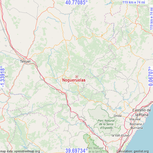
Nogueruelas GPS coordinates[2]
40° 14' 10.392" North, 0° 38' 9.816" West
| Map corner | latitude | longitude |
|---|---|---|
| Upper-left | 40.77085°, | -1.33918° |
| Center: | 40.23622°, | -0.63606° |
| Lower-right: | 39.69734°, | 0.06707° |
| Map W x H: | 119.4×119.4 km | = 74.2×74.2mi |
| max Lat: | 43.74134° ⇑66.6% North |
| Nogueruelas: | 40.23622° |
| min Lat: | ⇓33.4% South 27.64134° |
| min Long | Nogueruelas | max Long |
| -18.00367° | -0.63606° | 4.2899° |
| W 80.3%⇐ | ⇒19.7% E |
Elevation
Elevation of Nogueruelas is 1130 m = 3707 ft, and this is 532 m = 1745 ft above average elevation for this country.
| Max E: |
1682 m = 5518 ft | 5.3% |
| Nogueruelas | 1130 m 3707 ft | |
| Avg. | 598 m = 1962 ft | |
Min E: |
0 m = 0 ft | 94.7% |
See also: Spain elevation on elevation.city.
Geographical zone
Nogueruelas is located in North temperate zone (between Tropic of Cancer and the Arctic Circle). Distance of this Northern Tropic circle is 1867.9 km =1160.7 mi to South.| Distance of | km | miles | from Nogueruelas |
|---|---|---|---|
| North Pole | 5533.2 | 3438.2 | to North |
| Arctic Circle | 2927.3 | 1818.9 | to North |
| Tropic Cancer | 1867.9 | 1160.7 | to South |
| Equator | 4473.8 | 2779.9 | to South |


Nearby cities:
15 places around Nogueruelas: (largest is in red/bold)
• Albentosa
18.6 km =11.6 mi,  217°
217°
• Alcalá de la Selva
16.7 km =10.4 mi,  334°
334°
• Cabra de Mora
17 km =10.6 mi,  301°
301°
• Cortes de Arenoso
9.6 km =6 mi,  123°
123°
• Fuentes de Rubielos
7.9 km =4.9 mi,  167°
167°
• Linares de Mora
10.8 km =6.7 mi,  28°
28°
• Mora de Rubielos
10 km =6.2 mi,  278°
278°
• Olba
11.6 km =7.2 mi, 171°
• Puebla de Arenoso
15.8 km =9.8 mi,  163°
163°
• Puertomingalvo
15.5 km =9.6 mi,  78°
78°
• Rubielos de Mora
5.5 km =3.4 mi,  195°
195°
• Sarrión
18.5 km =11.5 mi,  235°
235°
• Valbona
14.9 km =9.3 mi,  266°
266°
• Valdelinares
17.4 km =10.8 mi,  8°
8°
• Villahermosa del Río
18.7 km =11.6 mi,  101°
101°
Sources, notices
• [Note1] Compared only with cities in Spain existing in our database
• [Src1] Map data: © OpenStreetMap contributors (CC-BY-SA)
• [Src2] Other city data from geonames.org with taken over terms of usage.
• [Src3] Geographical zone / Annual Mean Temperature by Robert A. Rohde @ Wikipedia
