Albentosa geodata
Albentosa (Aragon) is a seat of a third-order administrative division; located in Spain in Europe/Madrid (GMT+2) time zone. In our database, there are 6762 cities with bigger population. Compared to other cities in Spain, 68.7% of cities are located further ↑North; 79.2% of cities are located further ←West and 86.7% of cities have lower elevation than Albentosa. Note1


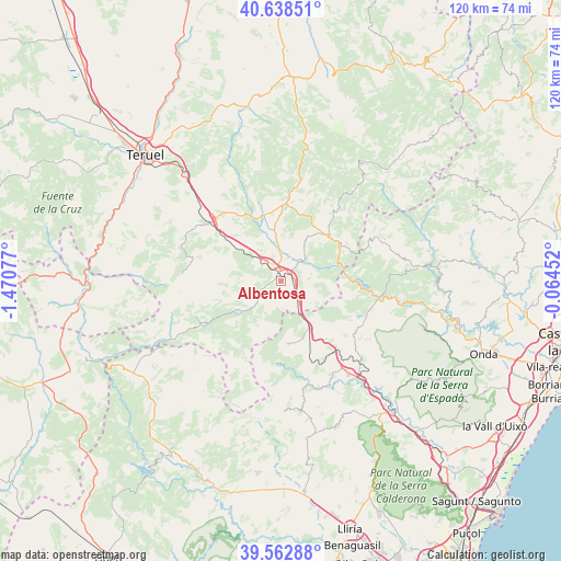
Albentosa GPS coordinates[2]
40° 6' 10.152" North, 0° 46' 3.504" West
| Map corner | latitude | longitude |
|---|---|---|
| Upper-left | 40.63851°, | -1.47077° |
| Center: | 40.10282°, | -0.76764° |
| Lower-right: | 39.56288°, | -0.06452° |
| Map W x H: | 119.6×119.6 km | = 74.3×74.3mi |
| max Lat: | 43.74134° ⇑68.7% North |
| Albentosa: | 40.10282° |
| min Lat: | ⇓31.3% South 27.64134° |
| min Long | Albentosa | max Long |
| -18.00367° | -0.76764° | 4.2899° |
| W 79.2%⇐ | ⇒20.8% E |
Elevation
Elevation of Albentosa is 976 m = 3202 ft, and this is 378 m = 1240 ft above average elevation for this country.
| Max E: |
1682 m = 5518 ft | 13.3% |
| Albentosa | 976 m 3202 ft | |
| Avg. | 598 m = 1962 ft | |
Min E: |
0 m = 0 ft | 86.7% |
See also: Spain elevation on elevation.city.
Geographical zone
Albentosa is located in North temperate zone (between Tropic of Cancer and the Arctic Circle). Distance of this Northern Tropic circle is 1853.1 km =1151.5 mi to South.| Distance of | km | miles | from Albentosa |
|---|---|---|---|
| North Pole | 5548 | 3447.4 | to North |
| Arctic Circle | 2942.2 | 1828.2 | to North |
| Tropic Cancer | 1853.1 | 1151.5 | to South |
| Equator | 4459 | 2770.7 | to South |


Nearby cities:
15 places around Albentosa: (largest is in red/bold)
• Barracas
12 km =7.5 mi,  143°
143°
• Fuente la Reina
14.8 km =9.2 mi,  105°
105°
• Fuentes de Rubielos
14.7 km =9.1 mi,  61°
61°
• Manzanera
8.1 km =5 mi,  223°
223°
• Mora de Rubielos
16.4 km =10.2 mi,  4°
4°
• Nogueruelas
18.6 km =11.6 mi,  37°
37°
• Olba
13.3 km =8.3 mi,  75°
75°
• Pina de Montalgrao
13.9 km =8.6 mi,  133°
133°
• Puebla de Arenoso
15.7 km =9.8 mi,  91°
91°
• Rubielos de Mora
13.7 km =8.5 mi,  45°
45°
• San Agustín
8 km =5 mi, 127°
• Sarrión
5.9 km =3.7 mi,  316°
316°
• Torrijas
18.2 km =11.3 mi,  238°
238°
• Valbona
14.5 km =9 mi,  345°
345°
• Villanueva de Viver
11.6 km =7.2 mi,  120°
120°
Sources, notices
• [Note1] Compared only with cities in Spain existing in our database
• [Src1] Map data: © OpenStreetMap contributors (CC-BY-SA)
• [Src2] Other city data from geonames.org with taken over terms of usage.
• [Src3] Geographical zone / Annual Mean Temperature by Robert A. Rohde @ Wikipedia
