Olba geodata
Olba (Aragon) is a seat of a third-order administrative division; located in Spain in Europe/Madrid (GMT+2) time zone. With population of 242 people, there are 4797 cities with bigger population in this country. Compared to other cities in Spain, 68.2% of cities are located further ↑North; 80.4% of cities are located further ←West and 51.1% of cities have higher elevation than Olba. Note1


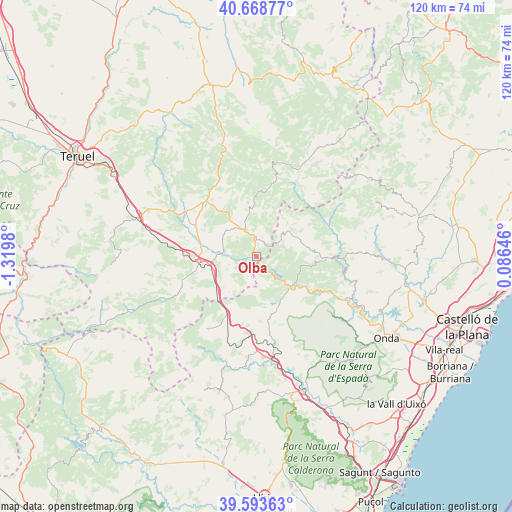
Olba GPS coordinates[2]
40° 7' 59.988" North, 0° 37' 0.012" West
| Map corner | latitude | longitude |
|---|---|---|
| Upper-left | 40.66877°, | -1.3198° |
| Center: | 40.13333°, | -0.61667° |
| Lower-right: | 39.59363°, | 0.08646° |
| Map W x H: | 119.5×119.5 km | = 74.3×74.3mi |
| max Lat: | 43.74134° ⇑68.2% North |
| Olba: | 40.13333° |
| min Lat: | ⇓31.8% South 27.64134° |
| min Long | Olba | max Long |
| -18.00367° | -0.61667° | 4.2899° |
| W 80.4%⇐ | ⇒19.6% E |
Elevation
Elevation of Olba is 647 m = 2123 ft, and this is 49 m = 161 ft above average elevation for this country.
| Max E: |
1682 m = 5518 ft | 51.1% |
| Olba | 647 m 2123 ft | |
| Avg. | 598 m = 1962 ft | |
Min E: |
0 m = 0 ft | 48.9% |
See also: Spain elevation on elevation.city.
Geographical zone
Olba is located in North temperate zone (between Tropic of Cancer and the Arctic Circle). Distance of this Northern Tropic circle is 1856.5 km =1153.6 mi to South.| Distance of | km | miles | from Olba |
|---|---|---|---|
| North Pole | 5544.7 | 3445.3 | to North |
| Arctic Circle | 2938.8 | 1826.1 | to North |
| Tropic Cancer | 1856.5 | 1153.6 | to South |
| Equator | 4462.4 | 2772.8 | to South |


Nearby cities:
15 places around Olba: (largest is in red/bold)
• Albentosa
13.3 km =8.3 mi,  255°
255°
• Arañuel
13.5 km =8.4 mi,  123°
123°
• Barracas
14.2 km =8.8 mi,  203°
203°
• Cirat
16.9 km =10.5 mi, 123°
• Cortes de Arenoso
8.8 km =5.5 mi,  46°
46°
• Fuente la Reina
7.5 km =4.7 mi,  169°
169°
• Fuentes de Rubielos
3.7 km =2.3 mi,  0°
0°
• Montanejos
11.3 km =7 mi,  131°
131°
• Montán
12.5 km =7.8 mi,  152°
152°
• Nogueruelas
11.6 km =7.2 mi,  351°
351°
• Pina de Montalgrao
13.3 km =8.3 mi,  192°
192°
• Puebla de Arenoso
4.7 km =2.9 mi,  142°
142°
• Rubielos de Mora
6.9 km =4.3 mi,  333°
333°
• San Agustín
10.5 km =6.5 mi,  218°
218°
• Villanueva de Viver
9.7 km =6 mi, 197°
Sources, notices
• [Note1] Compared only with cities in Spain existing in our database
• [Src1] Map data: © OpenStreetMap contributors (CC-BY-SA)
• [Src2] Other city data from geonames.org with taken over terms of usage.
• [Src3] Geographical zone / Annual Mean Temperature by Robert A. Rohde @ Wikipedia
