Congostrina geodata
Congostrina (Castille-La Mancha) is a seat of a third-order administrative division; located in Spain in Europe/Madrid (GMT+2) time zone. With population of 48 people, there are 6485 cities with bigger population in this country. Compared to other cities in Spain, 50.7% of cities are located further ↑North; 54.8% of cities are located further ←West and 89.2% of cities have lower elevation than Congostrina. Note1
Administrative division(s):
- Level 1: Castille-La Mancha
- Level 2: Provincia de Guadalajara
- Level 3: Congostrina


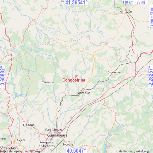
Congostrina GPS coordinates[2]
41° 2' 13.884" North, 2° 59' 8.484" West
| Map corner | latitude | longitude |
|---|---|---|
| Upper-left | 41.56541°, | -3.68882° |
| Center: | 41.03719°, | -2.98569° |
| Lower-right: | 40.5047°, | -2.28257° |
| Map W x H: | 117.9×117.9 km | = 73.3×73.3mi |
| max Lat: | 43.74134° ⇑50.7% North |
| Congostrina: | 41.03719° |
| min Lat: | ⇓49.3% South 27.64134° |
| min Long | Congostrina | max Long |
| -18.00367° | -2.98569° | 4.2899° |
| W 54.8%⇐ | ⇒45.2% E |
Elevation
Elevation of Congostrina is 1019 m = 3343 ft, and this is 421 m = 1381 ft above average elevation for this country.
| Max E: |
1682 m = 5518 ft | 10.8% |
| Congostrina | 1019 m 3343 ft | |
| Avg. | 598 m = 1962 ft | |
Min E: |
0 m = 0 ft | 89.2% |
See also: Spain elevation on elevation.city.
Geographical zone
Congostrina is located in North temperate zone (between Tropic of Cancer and the Arctic Circle). Distance of this Northern Tropic circle is 1957 km =1216 mi to South.| Distance of | km | miles | from Congostrina |
|---|---|---|---|
| North Pole | 5444.2 | 3382.9 | to North |
| Arctic Circle | 2838.3 | 1763.6 | to North |
| Tropic Cancer | 1957 | 1216 | to South |
| Equator | 4562.9 | 2835.3 | to South |


Nearby cities:
15 places around Congostrina: (largest is in red/bold)
• Gascueña de Bornova
12 km =7.5 mi,  346°
346°
• Hiendelaencina
5.4 km =3.4 mi,  344°
344°
• Jirueque
10.7 km =6.6 mi,  139°
139°
• Medranda
7.2 km =4.5 mi,  145°
145°
• Membrillera
9.9 km =6.2 mi,  177°
177°
• Monasterio
11 km =6.8 mi,  238°
238°
• Negredo
10.7 km =6.6 mi,  95°
95°
• Pinilla de Jadraque
4.1 km =2.5 mi,  118°
118°
• Pálmaces de Jadraque
6.6 km =4.1 mi,  71°
71°
• Robledo de Corpes
9.5 km =5.9 mi,  18°
18°
• San Andrés del Congosto
5.4 km =3.4 mi,  216°
216°
• Semillas
11.5 km =7.1 mi,  281°
281°
• Torremocha de Jadraque
7.5 km =4.7 mi,  105°
105°
• Villares de Jadraque
7.9 km =4.9 mi, 335°
• Zarzuela de Jadraque
6 km =3.7 mi,  305°
305°
Sources, notices
• [Note1] Compared only with cities in Spain existing in our database
• [Src1] Map data: © OpenStreetMap contributors (CC-BY-SA)
• [Src2] Other city data from geonames.org with taken over terms of usage.
• [Src3] Geographical zone / Annual Mean Temperature by Robert A. Rohde @ Wikipedia
