Manzanal del Barco geodata
Manzanal del Barco (Castille and León) is a seat of a third-order administrative division; located in Spain in Europe/Madrid (GMT+2) time zone. With population of 194 people, there are 5078 cities with bigger population in this country. Compared to other cities in Spain, 64.4% of cities are located further ↓South; 85.4% of cities are located further →East and 54.4% of cities have lower elevation than Manzanal del Barco. Note1
Administrative division(s):
- Level 1: Castille and León
- Level 2: Provincia de Zamora
- Level 3: Manzanal del Barco


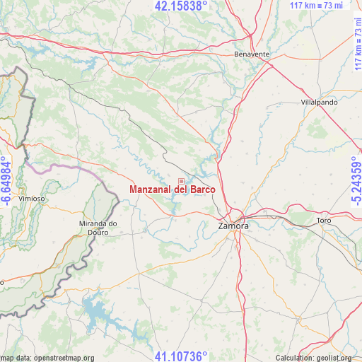
Manzanal del Barco GPS coordinates[2]
41° 38' 6.036" North, 5° 56' 48.156" West
| Map corner | latitude | longitude |
|---|---|---|
| Upper-left | 42.15838°, | -6.64984° |
| Center: | 41.63501°, | -5.94671° |
| Lower-right: | 41.10736°, | -5.24359° |
| Map W x H: | 116.9×116.9 km | = 72.6×72.6mi |
| max Lat: | 43.74134° ⇑35.6% North |
| Manzanal del Barco: | 41.63501° |
| min Lat: | ⇓64.4% South 27.64134° |
| min Long | Manzanal del Ba | max Long |
| -18.00367° | -5.94671° | 4.2899° |
| W 14.6%⇐ | ⇒85.4% E |
Elevation
Elevation of Manzanal del Barco is 704 m = 2310 ft, and this is 106 m = 348 ft above average elevation for this country.
| Max E: |
1682 m = 5518 ft | 45.6% |
| Manzanal del Barco | 704 m 2310 ft | |
| Avg. | 598 m = 1962 ft | |
Min E: |
0 m = 0 ft | 54.4% |
See also: Spain elevation on elevation.city.
Geographical zone
Manzanal del Barco is located in North temperate zone (between Tropic of Cancer and the Arctic Circle). Distance of this Northern Tropic circle is 2023.5 km =1257.3 mi to South.| Distance of | km | miles | from Manzanal del Barco |
|---|---|---|---|
| North Pole | 5377.7 | 3341.5 | to North |
| Arctic Circle | 2771.8 | 1722.3 | to North |
| Tropic Cancer | 2023.5 | 1257.3 | to South |
| Equator | 4629.4 | 2876.6 | to South |


Nearby cities:
15 places around Manzanal del Barco: (largest is in red/bold)
• Carbajales de Alba
4.7 km =2.9 mi,  296°
296°
• Fonfría
16.1 km =10 mi,  269°
269°
• Losacino
12.2 km =7.6 mi,  294°
294°
• Losacio
11.5 km =7.1 mi,  317°
317°
• Montamarta
11.9 km =7.4 mi,  83°
83°
• Muelas del Pan
12.8 km =8 mi,  188°
188°
• Olmillos de Castro
10.9 km =6.8 mi,  350°
350°
• Palacios del Pan
6.8 km =4.2 mi,  122°
122°
• Perilla de Castro
11.6 km =7.2 mi,  30°
30°
• Pozuelo de Tábara
17.2 km =10.7 mi,  14°
14°
• Roales
17.2 km =10.7 mi, 122°
• Santa Eufemia del Barco
6.3 km =3.9 mi,  40°
40°
• Vegalatrave
15.1 km =9.4 mi, 298°
• Videmala
8.2 km =5.1 mi,  252°
252°
• Villalcampo
15.1 km =9.4 mi,  213°
213°
Sources, notices
• [Note1] Compared only with cities in Spain existing in our database
• [Src1] Map data: © OpenStreetMap contributors (CC-BY-SA)
• [Src2] Other city data from geonames.org with taken over terms of usage.
• [Src3] Geographical zone / Annual Mean Temperature by Robert A. Rohde @ Wikipedia
