Madrigal de la Vera geodata
Madrigal de la Vera (Extremadura) is a seat of a third-order administrative division; located in Spain in Europe/Madrid (GMT+2) time zone. With population of 1,722 people, there are 2324 cities with bigger population in this country. Compared to other cities in Spain, 68% of cities are located further ↑North; 77.1% of cities are located further →East and 69.5% of cities have higher elevation than Madrigal de la Vera. Note1
Administrative division(s):
- Level 1: Extremadura
- Level 2: Provincia de Cáceres
- Level 3: Madrigal de la Vera


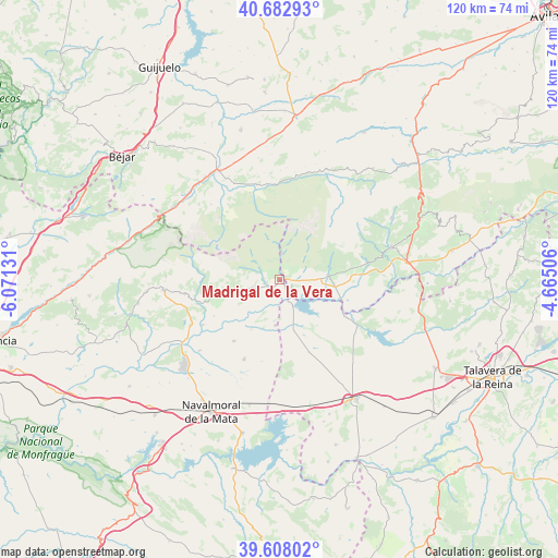
Madrigal de la Vera GPS coordinates[2]
40° 8' 51.36" North, 5° 22' 5.448" West
| Map corner | latitude | longitude |
|---|---|---|
| Upper-left | 40.68293°, | -6.07131° |
| Center: | 40.1476°, | -5.36818° |
| Lower-right: | 39.60802°, | -4.66506° |
| Map W x H: | 119.5×119.5 km | = 74.3×74.3mi |
| max Lat: | 43.74134° ⇑68% North |
| Madrigal de la Vera: | 40.1476° |
| min Lat: | ⇓32% South 27.64134° |
| min Long | Madrigal de la | max Long |
| -18.00367° | -5.36818° | 4.2899° |
| W 22.9%⇐ | ⇒77.1% E |
Elevation
Elevation of Madrigal de la Vera is 392 m = 1286 ft, and this is 206 m = 676 ft below average elevation for this country.
| Max E: |
1682 m = 5518 ft | 69.5% |
| Avg. | 598 m = 1962 ft | |
| Madrigal de la Vera | 392 m = 1286 ft | |
Min E: |
0 m = 0 ft | 30.5% |
See also: Spain elevation on elevation.city.
Geographical zone
Madrigal de la Vera is located in North temperate zone (between Tropic of Cancer and the Arctic Circle). Distance of this Northern Tropic circle is 1858.1 km =1154.6 mi to South.| Distance of | km | miles | from Madrigal de la Vera |
|---|---|---|---|
| North Pole | 5543.1 | 3444.3 | to North |
| Arctic Circle | 2937.2 | 1825.1 | to North |
| Tropic Cancer | 1858.1 | 1154.6 | to South |
| Equator | 4464 | 2773.8 | to South |


Nearby cities:
15 places around Madrigal de la Vera: (largest is in red/bold)
• Bohoyo
19.8 km =12.3 mi,  341°
341°
• Candeleda
10.9 km =6.8 mi,  85°
85°
• Guisando
21.1 km =13.1 mi,  66°
66°
• Losar de la Vera
20.3 km =12.6 mi,  261°
261°
• Nava del Barco
21.8 km =13.5 mi,  317°
317°
• Navalperal de Tormes
23.5 km =14.6 mi,  14°
14°
• Poyales del Hoyo
17.4 km =10.8 mi,  80°
80°
• Pueblonuevo de Miramontes
9.7 km =6 mi,  185°
185°
• Robledillo de la Vera
19.5 km =12.1 mi,  254°
254°
• Tiétar
16.3 km =10.1 mi,  216°
216°
• Tormellas
21.2 km =13.2 mi, 324°
• Valverde de la Vera
11.2 km =7 mi, 255°
• Viandar de la Vera
14.5 km =9 mi, 258°
• Villanueva de la Vera
8.3 km =5.2 mi, 256°
• Zapardiel de la Ribera
23.4 km =14.5 mi, 8°
Sources, notices
• [Note1] Compared only with cities in Spain existing in our database
• [Src1] Map data: © OpenStreetMap contributors (CC-BY-SA)
• [Src2] Other city data from geonames.org with taken over terms of usage.
• [Src3] Geographical zone / Annual Mean Temperature by Robert A. Rohde @ Wikipedia
