Guisando geodata
Guisando (Castille and León) is a seat of a third-order administrative division; located in Spain in Europe/Madrid (GMT+2) time zone. With population of 635 people, there are 3539 cities with bigger population in this country. Compared to other cities in Spain, 66.9% of cities are located further ↑North; 74.2% of cities are located further →East and 66.5% of cities have lower elevation than Guisando. Note1
Administrative division(s):
- Level 1: Castille and León
- Level 2: Provincia de Ávila
- Level 3: Guisando


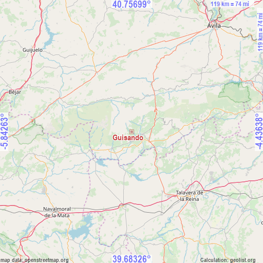
Guisando GPS coordinates[2]
40° 13' 20.1" North, 5° 8' 22.2" West
| Map corner | latitude | longitude |
|---|---|---|
| Upper-left | 40.75699°, | -5.84263° |
| Center: | 40.22225°, | -5.1395° |
| Lower-right: | 39.68326°, | -4.43638° |
| Map W x H: | 119.4×119.4 km | = 74.2×74.2mi |
| max Lat: | 43.74134° ⇑66.9% North |
| Guisando: | 40.22225° |
| min Lat: | ⇓33.1% South 27.64134° |
| min Long | Guisando | max Long |
| -18.00367° | -5.1395° | 4.2899° |
| W 25.8%⇐ | ⇒74.2% E |
Elevation
Elevation of Guisando is 788 m = 2585 ft, and this is 190 m = 623 ft above average elevation for this country.
| Max E: |
1682 m = 5518 ft | 33.5% |
| Guisando | 788 m 2585 ft | |
| Avg. | 598 m = 1962 ft | |
Min E: |
0 m = 0 ft | 66.5% |
See also: Spain elevation on elevation.city.
Geographical zone
Guisando is located in North temperate zone (between Tropic of Cancer and the Arctic Circle). Distance of this Northern Tropic circle is 1866.4 km =1159.7 mi to South.| Distance of | km | miles | from Guisando |
|---|---|---|---|
| North Pole | 5534.8 | 3439.2 | to North |
| Arctic Circle | 2928.9 | 1819.9 | to North |
| Tropic Cancer | 1866.4 | 1159.7 | to South |
| Equator | 4472.3 | 2779 | to South |


Nearby cities:
15 places around Guisando: (largest is in red/bold)
• Arenas de San Pedro
4.7 km =2.9 mi,  106°
106°
• Candeleda
11.4 km =7.1 mi,  228°
228°
• Cuevas del Valle
13.6 km =8.5 mi,  54°
54°
• Hoyos del Collado
16.1 km =10 mi,  341°
341°
• Hoyos del Espino
15.2 km =9.4 mi,  348°
348°
• Lanzahita
17.4 km =10.8 mi,  96°
96°
• Mombeltrán
11.2 km =7 mi,  68°
68°
• Navalcán
17.9 km =11.1 mi,  164°
164°
• Navarredonda de Gredos
15.5 km =9.6 mi,  2°
2°
• Parrillas
18.9 km =11.7 mi, 160°
• Poyales del Hoyo
6 km =3.7 mi,  202°
202°
• San Esteban del Valle
14.6 km =9.1 mi, 66°
• San Martín del Pimpollar
17.8 km =11.1 mi,  23°
23°
• Santa Cruz del Valle
12.2 km =7.6 mi, 74°
• Villarejo del Valle
14.1 km =8.8 mi,  59°
59°
Sources, notices
• [Note1] Compared only with cities in Spain existing in our database
• [Src1] Map data: © OpenStreetMap contributors (CC-BY-SA)
• [Src2] Other city data from geonames.org with taken over terms of usage.
• [Src3] Geographical zone / Annual Mean Temperature by Robert A. Rohde @ Wikipedia
