Madridanos geodata
Madridanos (Castille and León) is a seat of a third-order administrative division; located in Spain in Europe/Madrid (GMT+2) time zone. With population of 529 people, there are 3794 cities with bigger population in this country. Compared to other cities in Spain, 60.3% of cities are located further ↓South; 80.2% of cities are located further →East and 50.9% of cities have higher elevation than Madridanos. Note1
Administrative division(s):
- Level 1: Castille and León
- Level 2: Provincia de Zamora
- Level 3: Madridanos


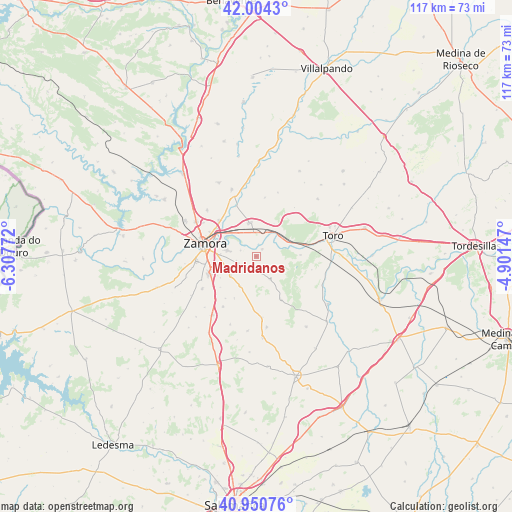
Madridanos GPS coordinates[2]
41° 28' 46.812" North, 5° 36' 16.524" West
| Map corner | latitude | longitude |
|---|---|---|
| Upper-left | 42.0043°, | -6.30772° |
| Center: | 41.47967°, | -5.60459° |
| Lower-right: | 40.95076°, | -4.90147° |
| Map W x H: | 117.1×117.1 km | = 72.8×72.8mi |
| max Lat: | 43.74134° ⇑39.7% North |
| Madridanos: | 41.47967° |
| min Lat: | ⇓60.3% South 27.64134° |
| min Long | Madridanos | max Long |
| -18.00367° | -5.60459° | 4.2899° |
| W 19.8%⇐ | ⇒80.2% E |
Elevation
Elevation of Madridanos is 649 m = 2129 ft, and this is 51 m = 167 ft above average elevation for this country.
| Max E: |
1682 m = 5518 ft | 50.9% |
| Madridanos | 649 m 2129 ft | |
| Avg. | 598 m = 1962 ft | |
Min E: |
0 m = 0 ft | 49.1% |
See also: Spain elevation on elevation.city.
Geographical zone
Madridanos is located in North temperate zone (between Tropic of Cancer and the Arctic Circle). Distance of this Northern Tropic circle is 2006.2 km =1246.6 mi to South.| Distance of | km | miles | from Madridanos |
|---|---|---|---|
| North Pole | 5395 | 3352.3 | to North |
| Arctic Circle | 2789.1 | 1733.1 | to North |
| Tropic Cancer | 2006.2 | 1246.6 | to South |
| Equator | 4612.1 | 2865.8 | to South |


Nearby cities:
15 places around Madridanos: (largest is in red/bold)
• Algodre
9.6 km =6 mi,  0°
0°
• Arcenillas
7.2 km =4.5 mi,  248°
248°
• Casaseca de las Chanas
7.5 km =4.7 mi,  232°
232°
• Cazurra
10.9 km =6.8 mi, 229°
• Coreses
7.7 km =4.8 mi,  348°
348°
• Fresno de la Ribera
6.4 km =4 mi,  29°
29°
• Gema
7.7 km =4.8 mi,  208°
208°
• Jambrina
10.9 km =6.8 mi, 206°
• Moraleja del Vino
4.7 km =2.9 mi, 247°
• Morales del Vino
11.1 km =6.9 mi, 251°
• Peleagonzalo
10.1 km =6.3 mi,  88°
88°
• Sanzoles
6.1 km =3.8 mi,  149°
149°
• Venialbo
11.5 km =7.1 mi, 150°
• Villalazán
2.1 km =1.3 mi,  38°
38°
• Villaralbo
6.7 km =4.2 mi,  281°
281°
Sources, notices
• [Note1] Compared only with cities in Spain existing in our database
• [Src1] Map data: © OpenStreetMap contributors (CC-BY-SA)
• [Src2] Other city data from geonames.org with taken over terms of usage.
• [Src3] Geographical zone / Annual Mean Temperature by Robert A. Rohde @ Wikipedia
