Villalazán geodata
Villalazán (Castille and León) is a seat of a third-order administrative division; located in Spain in Europe/Madrid (GMT+2) time zone. With population of 368 people, there are 4246 cities with bigger population in this country. Compared to other cities in Spain, 60.7% of cities are located further ↓South; 80% of cities are located further →East and 50.2% of cities have lower elevation than Villalazán. Note1
Administrative division(s):
- Level 1: Castille and León
- Level 2: Provincia de Zamora
- Level 3: Villalazán


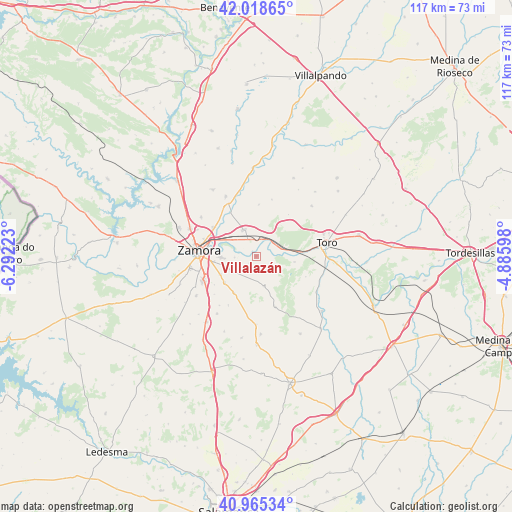
Villalazán GPS coordinates[2]
41° 29' 38.904" North, 5° 35' 20.76" West
| Map corner | latitude | longitude |
|---|---|---|
| Upper-left | 42.01865°, | -6.29223° |
| Center: | 41.49414°, | -5.5891° |
| Lower-right: | 40.96534°, | -4.88598° |
| Map W x H: | 117.1×117.1 km | = 72.8×72.8mi |
| max Lat: | 43.74134° ⇑39.3% North |
| Villalazán: | 41.49414° |
| min Lat: | ⇓60.7% South 27.64134° |
| min Long | Villalazán | max Long |
| -18.00367° | -5.5891° | 4.2899° |
| W 20%⇐ | ⇒80% E |
Elevation
Elevation of Villalazán is 661 m = 2169 ft, and this is 63 m = 207 ft above average elevation for this country.
| Max E: |
1682 m = 5518 ft | 49.8% |
| Villalazán | 661 m 2169 ft | |
| Avg. | 598 m = 1962 ft | |
Min E: |
0 m = 0 ft | 50.2% |
See also: Spain elevation on elevation.city.
Geographical zone
Villalazán is located in North temperate zone (between Tropic of Cancer and the Arctic Circle). Distance of this Northern Tropic circle is 2007.8 km =1247.6 mi to South.| Distance of | km | miles | from Villalazán |
|---|---|---|---|
| North Pole | 5393.3 | 3351.2 | to North |
| Arctic Circle | 2787.5 | 1732.1 | to North |
| Tropic Cancer | 2007.8 | 1247.6 | to South |
| Equator | 4613.7 | 2866.8 | to South |


Nearby cities:
15 places around Villalazán: (largest is in red/bold)
• Algodre
8.1 km =5 mi,  351°
351°
• Arcenillas
9 km =5.6 mi,  242°
242°
• Casaseca de las Chanas
9.5 km =5.9 mi,  229°
229°
• Coreses
6.6 km =4.1 mi,  335°
335°
• Fresno de la Ribera
4.3 km =2.7 mi,  25°
25°
• Gallegos del Pan
11.8 km =7.3 mi,  3°
3°
• Gema
9.8 km =6.1 mi,  210°
210°
• Madridanos
2.1 km =1.3 mi,  218°
218°
• Matilla la Seca
12 km =7.5 mi,  37°
37°
• Molacillos
11.5 km =7.1 mi,  328°
328°
• Monfarracinos
12 km =7.5 mi,  304°
304°
• Moraleja del Vino
6.5 km =4 mi, 238°
• Peleagonzalo
8.9 km =5.5 mi,  98°
98°
• Sanzoles
7.1 km =4.4 mi,  165°
165°
• Villaralbo
7.9 km =4.9 mi,  268°
268°
Sources, notices
• [Note1] Compared only with cities in Spain existing in our database
• [Src1] Map data: © OpenStreetMap contributors (CC-BY-SA)
• [Src2] Other city data from geonames.org with taken over terms of usage.
• [Src3] Geographical zone / Annual Mean Temperature by Robert A. Rohde @ Wikipedia
