Lazkao geodata
Lazkao (Basque Country) is a seat of a third-order administrative division; located in Spain in Europe/Madrid (GMT+2) time zone. In our database, there are 6762 cities with bigger population. Compared to other cities in Spain, 94.6% of cities are located further ↓South; 64.9% of cities are located further ←West and 82.8% of cities have higher elevation than Lazkao. Note1


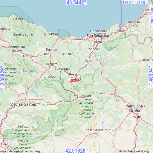
Lazkao GPS coordinates[2]
43° 1' 56.604" North, 2° 11' 10.176" West
| Map corner | latitude | longitude |
|---|---|---|
| Upper-left | 43.5442°, | -2.88929° |
| Center: | 43.03239°, | -2.18616° |
| Lower-right: | 42.51628°, | -1.48304° |
| Map W x H: | 114.3×114.3 km | = 71×71mi |
| max Lat: | 43.74134° ⇑5.4% North |
| Lazkao: | 43.03239° |
| min Lat: | ⇓94.6% South 27.64134° |
| min Long | Lazkao | max Long |
| -18.00367° | -2.18616° | 4.2899° |
| W 64.9%⇐ | ⇒35.1% E |
Elevation
Elevation of Lazkao is 170 m = 558 ft, and this is 428 m = 1404 ft below average elevation for this country.
| Max E: |
1682 m = 5518 ft | 82.8% |
| Avg. | 598 m = 1962 ft | |
| Lazkao | 170 m = 558 ft | |
Min E: |
0 m = 0 ft | 17.2% |
See also: Spain elevation on elevation.city.
Geographical zone
Lazkao is located in North temperate zone (between Tropic of Cancer and the Arctic Circle). Distance of this Northern Tropic circle is 2178.8 km =1353.8 mi to South.| Distance of | km | miles | from Lazkao |
|---|---|---|---|
| North Pole | 5222.3 | 3245 | to North |
| Arctic Circle | 2616.4 | 1625.8 | to North |
| Tropic Cancer | 2178.8 | 1353.8 | to South |
| Equator | 4784.8 | 2973.1 | to South |


Nearby cities:
15 places around Lazkao: (largest is in red/bold)
• Abaltzisketa
6.8 km =4.2 mi,  75°
75°
• Altzaga
4.4 km =2.7 mi,  36°
36°
• Arama
3.8 km =2.4 mi,  26°
26°
• Ataun
3 km =1.9 mi,  165°
165°
• Baliarrain
6.3 km =3.9 mi,  49°
49°
• Beasain
2.3 km =1.4 mi,  328°
328°
• Gaintza
4.9 km =3 mi,  62°
62°
• Idiazabal
4.5 km =2.8 mi,  239°
239°
• Itsasondo
4.4 km =2.7 mi,  23°
23°
• Legorreta
6.5 km =4 mi, 26°
• Olaberria
1.5 km =0.9 mi,  247°
247°
• Ordizia
2.5 km =1.6 mi, 18°
• Ormaiztegi
5.9 km =3.7 mi,  282°
282°
• Segura
6.2 km =3.9 mi, 243°
• Zaldibia
2.9 km =1.8 mi, 79°
Sources, notices
• [Note1] Compared only with cities in Spain existing in our database
• [Src1] Map data: © OpenStreetMap contributors (CC-BY-SA)
• [Src2] Other city data from geonames.org with taken over terms of usage.
• [Src3] Geographical zone / Annual Mean Temperature by Robert A. Rohde @ Wikipedia
