Arama geodata
Arama (Basque Country) is a seat of a third-order administrative division; located in Spain in Europe/Madrid (GMT+2) time zone. With population of 161 people, there are 5333 cities with bigger population in this country. Compared to other cities in Spain, 94.9% of cities are located further ↓South; 65.2% of cities are located further ←West and 83.2% of cities have higher elevation than Arama. Note1


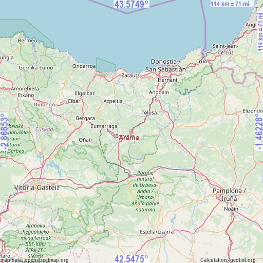
Arama GPS coordinates[2]
43° 3' 48.06" North, 2° 9' 55.44" West
| Map corner | latitude | longitude |
|---|---|---|
| Upper-left | 43.5749°, | -2.86853° |
| Center: | 43.06335°, | -2.1654° |
| Lower-right: | 42.5475°, | -1.46228° |
| Map W x H: | 114.2×114.2 km | = 71×71mi |
| max Lat: | 43.74134° ⇑5.1% North |
| Arama: | 43.06335° |
| min Lat: | ⇓94.9% South 27.64134° |
| min Long | Arama | max Long |
| -18.00367° | -2.1654° | 4.2899° |
| W 65.2%⇐ | ⇒34.8% E |
Elevation
Elevation of Arama is 166 m = 545 ft, and this is 432 m = 1417 ft below average elevation for this country.
| Max E: |
1682 m = 5518 ft | 83.2% |
| Avg. | 598 m = 1962 ft | |
| Arama | 166 m = 545 ft | |
Min E: |
0 m = 0 ft | 16.8% |
See also: Spain elevation on elevation.city.
Geographical zone
Arama is located in North temperate zone (between Tropic of Cancer and the Arctic Circle). Distance of this Northern Tropic circle is 2182.3 km =1356 mi to South.| Distance of | km | miles | from Arama |
|---|---|---|---|
| North Pole | 5218.9 | 3242.9 | to North |
| Arctic Circle | 2613 | 1623.6 | to North |
| Tropic Cancer | 2182.3 | 1356 | to South |
| Equator | 4788.2 | 2975.2 | to South |


Nearby cities:
15 places around Arama: (largest is in red/bold)
• Abaltzisketa
5.2 km =3.2 mi,  109°
109°
• Altzaga
0.9 km =0.6 mi,  80°
80°
• Amezketa
6.7 km =4.2 mi,  104°
104°
• Ataun
6.4 km =4 mi,  188°
188°
• Baliarrain
3.1 km =1.9 mi, 77°
• Beasain
3.2 km =2 mi,  243°
243°
• Gaintza
2.9 km =1.8 mi, 114°
• Ikaztegieta
4.8 km =3 mi,  44°
44°
• Itsasondo
0.6 km =0.4 mi,  5°
5°
• Lazkao
3.8 km =2.4 mi,  206°
206°
• Legorreta
2.7 km =1.7 mi,  27°
27°
• Olaberria
5.1 km =3.2 mi,  217°
217°
• Ordizia
1.4 km =0.9 mi, 220°
• Orendain
4.7 km =2.9 mi,  68°
68°
• Zaldibia
3.1 km =1.9 mi,  157°
157°
Sources, notices
• [Note1] Compared only with cities in Spain existing in our database
• [Src1] Map data: © OpenStreetMap contributors (CC-BY-SA)
• [Src2] Other city data from geonames.org with taken over terms of usage.
• [Src3] Geographical zone / Annual Mean Temperature by Robert A. Rohde @ Wikipedia
