Altzaga geodata
Altzaga (Basque Country) is a seat of a third-order administrative division; located in Spain in Europe/Madrid (GMT+2) time zone. In our database, there are 6762 cities with bigger population. Compared to other cities in Spain, 95% of cities are located further ↓South; 65.4% of cities are located further ←West and 74.8% of cities have higher elevation than Altzaga. Note1


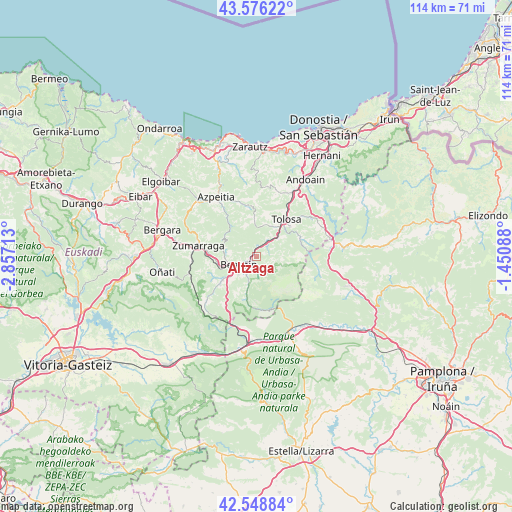
Altzaga GPS coordinates[2]
43° 3' 52.848" North, 2° 9' 14.4" West
| Map corner | latitude | longitude |
|---|---|---|
| Upper-left | 43.57622°, | -2.85713° |
| Center: | 43.06468°, | -2.154° |
| Lower-right: | 42.54884°, | -1.45088° |
| Map W x H: | 114.2×114.2 km | = 71×71mi |
| max Lat: | 43.74134° ⇑5% North |
| Altzaga: | 43.06468° |
| min Lat: | ⇓95% South 27.64134° |
| min Long | Altzaga | max Long |
| -18.00367° | -2.154° | 4.2899° |
| W 65.4%⇐ | ⇒34.6% E |
Elevation
Elevation of Altzaga is 298 m = 978 ft, and this is 300 m = 984 ft below average elevation for this country.
| Max E: |
1682 m = 5518 ft | 74.8% |
| Avg. | 598 m = 1962 ft | |
| Altzaga | 298 m = 978 ft | |
Min E: |
0 m = 0 ft | 25.2% |
See also: Spain elevation on elevation.city.
Geographical zone
Altzaga is located in North temperate zone (between Tropic of Cancer and the Arctic Circle). Distance of this Northern Tropic circle is 2182.4 km =1356.1 mi to South.| Distance of | km | miles | from Altzaga |
|---|---|---|---|
| North Pole | 5218.7 | 3242.7 | to North |
| Arctic Circle | 2612.8 | 1623.5 | to North |
| Tropic Cancer | 2182.4 | 1356.1 | to South |
| Equator | 4788.3 | 2975.3 | to South |


Nearby cities:
15 places around Altzaga: (largest is in red/bold)
• Abaltzisketa
4.4 km =2.7 mi,  115°
115°
• Alegia
6.2 km =3.9 mi,  49°
49°
• Amezketa
5.9 km =3.7 mi,  108°
108°
• Arama
0.9 km =0.6 mi,  260°
260°
• Baliarrain
2.2 km =1.4 mi,  76°
76°
• Beasain
4.1 km =2.5 mi,  247°
247°
• Gaintza
2.2 km =1.4 mi,  127°
127°
• Ikaztegieta
4.1 km =2.5 mi,  36°
36°
• Itsasondo
1 km =0.6 mi,  299°
299°
• Lazkao
4.4 km =2.7 mi,  216°
216°
• Legorreta
2.2 km =1.4 mi,  7°
7°
• Olaberria
5.8 km =3.6 mi, 224°
• Ordizia
2.2 km =1.4 mi,  237°
237°
• Orendain
3.8 km =2.4 mi,  65°
65°
• Zaldibia
3.1 km =1.9 mi,  174°
174°
Sources, notices
• [Note1] Compared only with cities in Spain existing in our database
• [Src1] Map data: © OpenStreetMap contributors (CC-BY-SA)
• [Src2] Other city data from geonames.org with taken over terms of usage.
• [Src3] Geographical zone / Annual Mean Temperature by Robert A. Rohde @ Wikipedia
