Langa geodata
Langa (Castille and León) is a seat of a third-order administrative division; located in Spain in Europe/Madrid (GMT+2) time zone. With population of 550 people, there are 3739 cities with bigger population in this country. Compared to other cities in Spain, 51.4% of cities are located further ↑North; 70.6% of cities are located further →East and 76.9% of cities have lower elevation than Langa. Note1


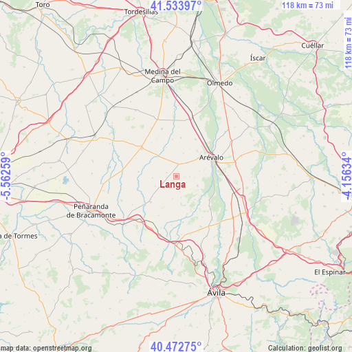
Langa GPS coordinates[2]
41° 0' 19.8" North, 4° 51' 34.056" West
| Map corner | latitude | longitude |
|---|---|---|
| Upper-left | 41.53397°, | -5.56259° |
| Center: | 41.0055°, | -4.85946° |
| Lower-right: | 40.47275°, | -4.15634° |
| Map W x H: | 118×118 km | = 73.3×73.3mi |
| max Lat: | 43.74134° ⇑51.4% North |
| Langa: | 41.0055° |
| min Lat: | ⇓48.6% South 27.64134° |
| min Long | Langa | max Long |
| -18.00367° | -4.85946° | 4.2899° |
| W 29.4%⇐ | ⇒70.6% E |
Elevation
Elevation of Langa is 870 m = 2854 ft, and this is 272 m = 892 ft above average elevation for this country.
| Max E: |
1682 m = 5518 ft | 23.1% |
| Langa | 870 m 2854 ft | |
| Avg. | 598 m = 1962 ft | |
Min E: |
0 m = 0 ft | 76.9% |
See also: Spain elevation on elevation.city.
Geographical zone
Langa is located in North temperate zone (between Tropic of Cancer and the Arctic Circle). Distance of this Northern Tropic circle is 1953.5 km =1213.8 mi to South.| Distance of | km | miles | from Langa |
|---|---|---|---|
| North Pole | 5447.7 | 3385 | to North |
| Arctic Circle | 2841.8 | 1765.8 | to North |
| Tropic Cancer | 1953.5 | 1213.8 | to South |
| Equator | 4559.4 | 2833.1 | to South |


Nearby cities:
15 places around Langa: (largest is in red/bold)
• Aldeaseca
6 km =3.7 mi,  36°
36°
• Barromán
8.9 km =5.5 mi,  318°
318°
• Bercial de Zapardiel
10.3 km =6.4 mi,  296°
296°
• Cabezas de Alambre
7.2 km =4.5 mi,  168°
168°
• Cabezas del Pozo
8 km =5 mi,  266°
266°
• Canales
3.5 km =2.2 mi, 266°
• Cantiveros
9.9 km =6.2 mi,  233°
233°
• Castellanos de Zapardiel
9.7 km =6 mi,  334°
334°
• Constanzana
7.6 km =4.7 mi,  189°
189°
• Donjimeno
5.2 km =3.2 mi, 167°
• Fuentes de Año
3.6 km =2.2 mi,  292°
292°
• Nava de Arévalo
7.7 km =4.8 mi,  113°
113°
• San Vicente de Arévalo
6.4 km =4 mi,  131°
131°
• Sinlabajos
8.2 km =5.1 mi,  16°
16°
• Villanueva del Aceral
4 km =2.5 mi,  6°
6°
Sources, notices
• [Note1] Compared only with cities in Spain existing in our database
• [Src1] Map data: © OpenStreetMap contributors (CC-BY-SA)
• [Src2] Other city data from geonames.org with taken over terms of usage.
• [Src3] Geographical zone / Annual Mean Temperature by Robert A. Rohde @ Wikipedia
