Barromán geodata
Barromán (Castille and León) is a seat of a third-order administrative division; located in Spain in Europe/Madrid (GMT+2) time zone. With population of 221 people, there are 4905 cities with bigger population in this country. Compared to other cities in Spain, 50.1% of cities are located further ↓South; 71.6% of cities are located further →East and 67.5% of cities have lower elevation than Barromán. Note1
Administrative division(s):
- Level 1: Castille and León
- Level 2: Provincia de Ávila
- Level 3: Barromán


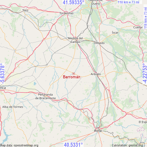
Barromán GPS coordinates[2]
41° 3' 55.296" North, 4° 55' 50.376" West
| Map corner | latitude | longitude |
|---|---|---|
| Upper-left | 41.59335°, | -5.63378° |
| Center: | 41.06536°, | -4.93066° |
| Lower-right: | 40.5331°, | -4.22753° |
| Map W x H: | 117.9×117.9 km | = 73.3×73.3mi |
| max Lat: | 43.74134° ⇑49.9% North |
| Barromán: | 41.06536° |
| min Lat: | ⇓50.1% South 27.64134° |
| min Long | Barromán | max Long |
| -18.00367° | -4.93066° | 4.2899° |
| W 28.4%⇐ | ⇒71.6% E |
Elevation
Elevation of Barromán is 795 m = 2608 ft, and this is 197 m = 646 ft above average elevation for this country.
| Max E: |
1682 m = 5518 ft | 32.5% |
| Barromán | 795 m 2608 ft | |
| Avg. | 598 m = 1962 ft | |
Min E: |
0 m = 0 ft | 67.5% |
See also: Spain elevation on elevation.city.
Geographical zone
Barromán is located in North temperate zone (between Tropic of Cancer and the Arctic Circle). Distance of this Northern Tropic circle is 1960.1 km =1217.9 mi to South.| Distance of | km | miles | from Barromán |
|---|---|---|---|
| North Pole | 5441 | 3380.9 | to North |
| Arctic Circle | 2835.1 | 1761.6 | to North |
| Tropic Cancer | 1960.1 | 1217.9 | to South |
| Equator | 4566 | 2837.2 | to South |


Nearby cities:
15 places around Barromán: (largest is in red/bold)
• Aldeaseca
9.7 km =6 mi,  100°
100°
• Bercial de Zapardiel
3.8 km =2.4 mi,  237°
237°
• Cabezas del Pozo
7.4 km =4.6 mi,  195°
195°
• Canales
7.3 km =4.5 mi,  160°
160°
• Castellanos de Zapardiel
2.8 km =1.7 mi,  39°
39°
• Donvidas
10.8 km =6.7 mi,  75°
75°
• Fuente el Sol
12.3 km =7.6 mi,  358°
358°
• Fuentes de Año
5.9 km =3.7 mi,  153°
153°
• Langa
8.9 km =5.5 mi,  138°
138°
• Madrigal de las Altas Torres
6.3 km =3.9 mi,  295°
295°
• Mamblas
8.3 km =5.2 mi,  231°
231°
• Moraleja de Matacabras
5.2 km =3.2 mi,  334°
334°
• Salvador de Zapardiel
7.4 km =4.6 mi, 39°
• Sinlabajos
8.3 km =5.2 mi, 81°
• Villanueva del Aceral
7 km =4.3 mi,  112°
112°
Sources, notices
• [Note1] Compared only with cities in Spain existing in our database
• [Src1] Map data: © OpenStreetMap contributors (CC-BY-SA)
• [Src2] Other city data from geonames.org with taken over terms of usage.
• [Src3] Geographical zone / Annual Mean Temperature by Robert A. Rohde @ Wikipedia
