L'Ametlla del Vallès geodata
L'Ametlla del Vallès (Catalonia) is a populated place; located in Spain in Europe/Madrid (GMT+2) time zone. With population of 7,319 people, there are 1003 cities with bigger population in this country. Compared to other cities in Spain, 65.1% of cities are located further ↓South; 95.7% of cities are located further ←West and 77.3% of cities have higher elevation than L'Ametlla del Vallès. Note1
Administrative division(s):
- Level 1: Catalonia
- Level 2: Província de Barcelona
- Level 3: l'Ametlla del Vallès


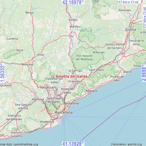
L'Ametlla del Vallès GPS coordinates[2]
41° 40' 0.012" North, 2° 16' 0.012" East
| Map corner | latitude | longitude |
|---|---|---|
| Upper-left | 42.18978°, | 1.56355° |
| Center: | 41.66667°, | 2.26667° |
| Lower-right: | 41.13928°, | 2.9698° |
| Map W x H: | 116.8×116.8 km | = 72.6×72.6mi |
| max Lat: | 43.74134° ⇑34.9% North |
| L'Ametlla del Vallès: | 41.66667° |
| min Lat: | ⇓65.1% South 27.64134° |
| min Long | L'Ametlla del V | max Long |
| -18.00367° | 2.26667° | 4.2899° |
| W 95.7%⇐ | ⇒4.3% E |
Elevation
Elevation of L'Ametlla del Vallès is 266 m = 873 ft, and this is 332 m = 1089 ft below average elevation for this country.
| Max E: |
1682 m = 5518 ft | 77.3% |
| Avg. | 598 m = 1962 ft | |
| L'Ametlla del Vallès | 266 m = 873 ft | |
Min E: |
0 m = 0 ft | 22.7% |
See also: Spain elevation on elevation.city.
Geographical zone
L'Ametlla del Vallès is located in North temperate zone (between Tropic of Cancer and the Arctic Circle). Distance of this Northern Tropic circle is 2027 km =1259.5 mi to South.| Distance of | km | miles | from L'Ametlla del Vallès |
|---|---|---|---|
| North Pole | 5374.2 | 3339.4 | to North |
| Arctic Circle | 2768.3 | 1720.1 | to North |
| Tropic Cancer | 2027 | 1259.5 | to South |
| Equator | 4632.9 | 2878.7 | to South |


Nearby cities:
15 places around L'Ametlla del Vallès: (largest is in red/bold)
• Bigues i Riells
3.3 km =2.1 mi,  303°
303°
• Caldes de Montbui
9.1 km =5.7 mi,  245°
245°
• Canovelles
5.7 km =3.5 mi,  166°
166°
• Cardedeu
8.1 km =5 mi,  111°
111°
• Cànoves i Samalús
7.2 km =4.5 mi,  75°
75°
• Figaró
6.1 km =3.8 mi,  4°
4°
• Granollers
6.8 km =4.2 mi,  164°
164°
• Les Franqueses del Vallès
5.9 km =3.7 mi,  153°
153°
• Lliçà d'Amunt
6.2 km =3.9 mi,  206°
206°
• Lliçà de Vall
8.7 km =5.4 mi,  194°
194°
• Sant Feliu de Codines
9.1 km =5.7 mi,  294°
294°
• Sant Pere de Vilamajor
9.9 km =6.2 mi, 79°
• Santa Eulàlia de Ronçana
3.3 km =2.1 mi,  236°
236°
• Tagamanent
7.9 km =4.9 mi, 0°
• la Garriga
2.3 km =1.4 mi,  36°
36°
Sources, notices
• [Note1] Compared only with cities in Spain existing in our database
• [Src1] Map data: © OpenStreetMap contributors (CC-BY-SA)
• [Src2] Other city data from geonames.org with taken over terms of usage.
• [Src3] Geographical zone / Annual Mean Temperature by Robert A. Rohde @ Wikipedia
