Huérguina geodata
Huérguina (Castille-La Mancha) is a seat of a third-order administrative division; located in Spain in Europe/Madrid (GMT+2) time zone. With population of 94 people, there are 6009 cities with bigger population in this country. Compared to other cities in Spain, 69.8% of cities are located further ↑North; 72% of cities are located further ←West and 98% of cities have lower elevation than Huérguina. Note1
Administrative division(s):
- Level 1: Castille-La Mancha
- Level 2: Provincia de Cuenca
- Level 3: Huérguina


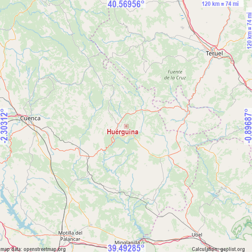
Huérguina GPS coordinates[2]
40° 1' 59.988" North, 1° 36' 0" West
| Map corner | latitude | longitude |
|---|---|---|
| Upper-left | 40.56956°, | -2.30312° |
| Center: | 40.03333°, | -1.6° |
| Lower-right: | 39.49285°, | -0.89687° |
| Map W x H: | 119.7×119.7 km | = 74.4×74.4mi |
| max Lat: | 43.74134° ⇑69.8% North |
| Huérguina: | 40.03333° |
| min Lat: | ⇓30.2% South 27.64134° |
| min Long | Huérguina | max Long |
| -18.00367° | -1.6° | 4.2899° |
| W 72%⇐ | ⇒28% E |
Elevation
Elevation of Huérguina is 1254 m = 4114 ft, and this is 656 m = 2152 ft above average elevation for this country.
| Max E: |
1682 m = 5518 ft | 2% |
| Huérguina | 1254 m 4114 ft | |
| Avg. | 598 m = 1962 ft | |
Min E: |
0 m = 0 ft | 98% |
See also: Spain elevation on elevation.city.
Geographical zone
Huérguina is located in North temperate zone (between Tropic of Cancer and the Arctic Circle). Distance of this Northern Tropic circle is 1845.4 km =1146.7 mi to South.| Distance of | km | miles | from Huérguina |
|---|---|---|---|
| North Pole | 5555.8 | 3452.2 | to North |
| Arctic Circle | 2949.9 | 1833 | to North |
| Tropic Cancer | 1845.4 | 1146.7 | to South |
| Equator | 4451.3 | 2765.9 | to South |


Nearby cities:
15 places around Huérguina: (largest is in red/bold)
• Alcalá de la Vega
7.1 km =4.4 mi,  90°
90°
• Algarra
14.7 km =9.1 mi,  104°
104°
• Boniches
5.7 km =3.5 mi,  194°
194°
• Campillos-Paravientos
7 km =4.3 mi,  142°
142°
• Campillos-Sierra
11.3 km =7 mi,  311°
311°
• Casas de Garcimolina
16 km =9.9 mi, 103°
• Cañete
4.6 km =2.9 mi,  293°
293°
• Huerta del Marquesado
14.8 km =9.2 mi,  331°
331°
• Pajaroncillo
14.7 km =9.1 mi,  230°
230°
• Salinas del Manzano
7 km =4.3 mi,  37°
37°
• Salvacañete
11.3 km =7 mi,  48°
48°
• San Martín de Boniches
15.1 km =9.4 mi,  169°
169°
• Tejadillos
11.5 km =7.1 mi,  345°
345°
• Valdemorillo de la Sierra
15.6 km =9.7 mi,  270°
270°
• Valdemoro-Sierra
16 km =9.9 mi,  297°
297°
Sources, notices
• [Note1] Compared only with cities in Spain existing in our database
• [Src1] Map data: © OpenStreetMap contributors (CC-BY-SA)
• [Src2] Other city data from geonames.org with taken over terms of usage.
• [Src3] Geographical zone / Annual Mean Temperature by Robert A. Rohde @ Wikipedia
