Salvacañete geodata
Salvacañete (Castille-La Mancha) is a seat of a third-order administrative division; located in Spain in Europe/Madrid (GMT+2) time zone. With population of 337 people, there are 4364 cities with bigger population in this country. Compared to other cities in Spain, 68.9% of cities are located further ↑North; 72.9% of cities are located further ←West and 96.2% of cities have lower elevation than Salvacañete. Note1
Administrative division(s):
- Level 1: Castille-La Mancha
- Level 2: Provincia de Cuenca
- Level 3: Salvacañete


Salvacañete GPS coordinates[2]
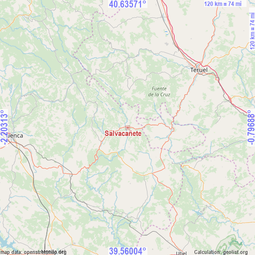
40° 6' 0" North, 1° 30' 0" West
| Map corner | latitude | longitude |
|---|---|---|
| Upper-left | 40.63571°, | -2.20313° |
| Center: | 40.1°, | -1.5° |
| Lower-right: | 39.56004°, | -0.79688° |
| Map W x H: | 119.6×119.6 km | = 74.3×74.3mi |
| max Lat: | 43.74134° ⇑68.9% North |
| Salvacañete: | 40.1° |
| min Lat: | ⇓31.1% South 27.64134° |
| min Long | Salvacañete | max Long |
| -18.00367° | -1.5° | 4.2899° |
| W 72.9%⇐ | ⇒27.1% E |
Elevation
Elevation of Salvacañete is 1179 m = 3868 ft, and this is 581 m = 1906 ft above average elevation for this country.
| Max E: |
1682 m = 5518 ft | 3.8% |
| Salvacañete | 1179 m 3868 ft | |
| Avg. | 598 m = 1962 ft | |
Min E: |
0 m = 0 ft | 96.2% |
See also: Spain elevation on elevation.city.
Geographical zone
Salvacañete is located in North temperate zone (between Tropic of Cancer and the Arctic Circle). Distance of this Northern Tropic circle is 1852.8 km =1151.3 mi to South.| Distance of | km | miles | from Salvacañete |
|---|---|---|---|
| North Pole | 5548.4 | 3447.6 | to North |
| Arctic Circle | 2942.5 | 1828.4 | to North |
| Tropic Cancer | 1852.8 | 1151.3 | to South |
| Equator | 4458.7 | 2770.5 | to South |


Nearby cities:
15 places around Salvacañete: (largest is in red/bold)
• Alcalá de la Vega
7.5 km =4.7 mi,  190°
190°
• Algarra
12.5 km =7.8 mi,  152°
152°
• Alobras
13.2 km =8.2 mi,  46°
46°
• Boniches
16.3 km =10.1 mi,  217°
217°
• Campillos-Paravientos
13.7 km =8.5 mi,  198°
198°
• Casas de Garcimolina
13.2 km =8.2 mi, 147°
• Cañete
13.9 km =8.6 mi,  246°
246°
• Huerta del Marquesado
16.5 km =10.3 mi,  289°
289°
• Huérguina
11.3 km =7 mi,  228°
228°
• Salinas del Manzano
4.6 km =2.9 mi, 246°
• Tejadillos
11.9 km =7.4 mi, 288°
• Tormón
16.9 km =10.5 mi, 47°
• Vallanca
14.7 km =9.1 mi,  104°
104°
• Veguillas de la Sierra
10.2 km =6.3 mi,  56°
56°
• Zafrilla
14.9 km =9.3 mi,  318°
318°
Sources, notices
• [Note1] Compared only with cities in Spain existing in our database
• [Src1] Map data: © OpenStreetMap contributors (CC-BY-SA)
• [Src2] Other city data from geonames.org with taken over terms of usage.
• [Src3] Geographical zone / Annual Mean Temperature by Robert A. Rohde @ Wikipedia
