Hoyorredondo geodata
Hoyorredondo (Castille and León) is a seat of a third-order administrative division; located in Spain in Europe/Madrid (GMT+2) time zone. With population of 107 people, there are 5841 cities with bigger population in this country. Compared to other cities in Spain, 62.6% of cities are located further ↑North; 77.5% of cities are located further →East and 90.6% of cities have lower elevation than Hoyorredondo. Note1
Administrative division(s):
- Level 1: Castille and León
- Level 2: Provincia de Ávila
- Level 3: Hoyorredondo


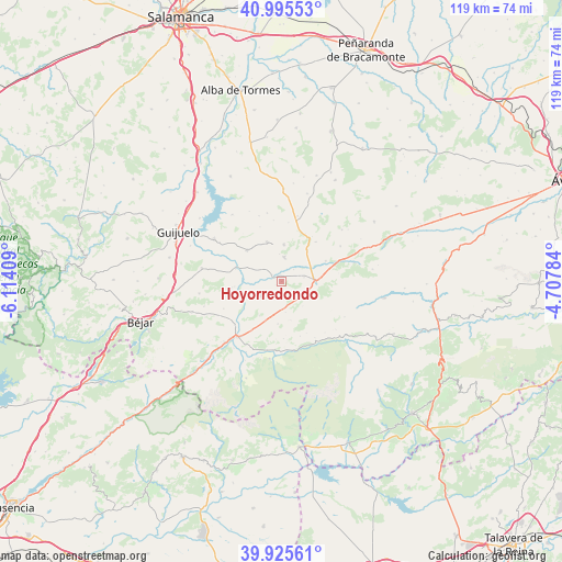
Hoyorredondo GPS coordinates[2]
40° 27' 45.72" North, 5° 24' 39.492" West
| Map corner | latitude | longitude |
|---|---|---|
| Upper-left | 40.99553°, | -6.11409° |
| Center: | 40.4627°, | -5.41097° |
| Lower-right: | 39.92561°, | -4.70784° |
| Map W x H: | 119×119 km | = 73.9×73.9mi |
| max Lat: | 43.74134° ⇑62.6% North |
| Hoyorredondo: | 40.4627° |
| min Lat: | ⇓37.4% South 27.64134° |
| min Long | Hoyorredondo | max Long |
| -18.00367° | -5.41097° | 4.2899° |
| W 22.5%⇐ | ⇒77.5% E |
Elevation
Elevation of Hoyorredondo is 1042 m = 3419 ft, and this is 444 m = 1457 ft above average elevation for this country.
| Max E: |
1682 m = 5518 ft | 9.4% |
| Hoyorredondo | 1042 m 3419 ft | |
| Avg. | 598 m = 1962 ft | |
Min E: |
0 m = 0 ft | 90.6% |
See also: Spain elevation on elevation.city.
Geographical zone
Hoyorredondo is located in North temperate zone (between Tropic of Cancer and the Arctic Circle). Distance of this Northern Tropic circle is 1893.1 km =1176.3 mi to South.| Distance of | km | miles | from Hoyorredondo |
|---|---|---|---|
| North Pole | 5508 | 3422.5 | to North |
| Arctic Circle | 2902.1 | 1803.3 | to North |
| Tropic Cancer | 1893.1 | 1176.3 | to South |
| Equator | 4499 | 2795.5 | to South |


Nearby cities:
15 places around Hoyorredondo: (largest is in red/bold)
• Aldeanueva de Santa Cruz
9 km =5.6 mi,  185°
185°
• Avellaneda
8.4 km =5.2 mi,  166°
166°
• Becedillas
11.1 km =6.9 mi,  40°
40°
• Collado del Mirón
11.1 km =6.9 mi,  25°
25°
• La Horcajada
5.5 km =3.4 mi,  238°
238°
• Malpartida de Corneja
8.4 km =5.2 mi, 37°
• Mesegar de Corneja
10.3 km =6.4 mi,  64°
64°
• Navamorales
5.9 km =3.7 mi,  284°
284°
• Puente del Congosto
10.2 km =6.3 mi,  287°
287°
• San Bartolomé de Corneja
4 km =2.5 mi, 33°
• San Miguel de Corneja
10.9 km =6.8 mi,  75°
75°
• Santa María de los Caballeros
8.8 km =5.5 mi,  202°
202°
• Santa María del Berrocal
5.1 km =3.2 mi,  5°
5°
• Santiago del Collado
5.7 km =3.5 mi,  125°
125°
• Villar de Corneja
2.3 km =1.4 mi,  305°
305°
Sources, notices
• [Note1] Compared only with cities in Spain existing in our database
• [Src1] Map data: © OpenStreetMap contributors (CC-BY-SA)
• [Src2] Other city data from geonames.org with taken over terms of usage.
• [Src3] Geographical zone / Annual Mean Temperature by Robert A. Rohde @ Wikipedia
