Hostalric geodata
Hostalric (Catalonia) is a seat of a third-order administrative division; located in Spain in Europe/Madrid (GMT+2) time zone. With population of 3,442 people, there are 1600 cities with bigger population in this country. Compared to other cities in Spain, 67.3% of cities are located further ↓South; 96.9% of cities are located further ←West and 89.9% of cities have higher elevation than Hostalric. Note1


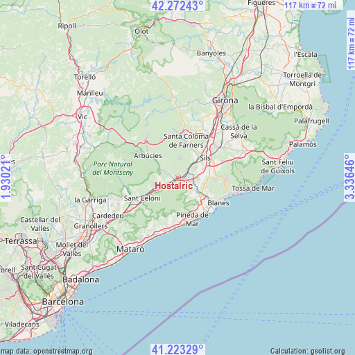
Hostalric GPS coordinates[2]
41° 45' 0" North, 2° 37' 59.988" East
| Map corner | latitude | longitude |
|---|---|---|
| Upper-left | 42.27243°, | 1.93021° |
| Center: | 41.75°, | 2.63333° |
| Lower-right: | 41.22329°, | 3.33646° |
| Map W x H: | 116.7×116.7 km | = 72.5×72.5mi |
| max Lat: | 43.74134° ⇑32.7% North |
| Hostalric: | 41.75° |
| min Lat: | ⇓67.3% South 27.64134° |
| min Long | Hostalric | max Long |
| -18.00367° | 2.63333° | 4.2899° |
| W 96.9%⇐ | ⇒3.1% E |
Elevation
Elevation of Hostalric is 67 m = 220 ft, and this is 531 m = 1742 ft below average elevation for this country.
| Max E: |
1682 m = 5518 ft | 89.9% |
| Avg. | 598 m = 1962 ft | |
| Hostalric | 67 m = 220 ft | |
Min E: |
0 m = 0 ft | 10.1% |
See also: Spain elevation on elevation.city.
Geographical zone
Hostalric is located in North temperate zone (between Tropic of Cancer and the Arctic Circle). Distance of this Northern Tropic circle is 2036.2 km =1265.2 mi to South.| Distance of | km | miles | from Hostalric |
|---|---|---|---|
| North Pole | 5364.9 | 3333.6 | to North |
| Arctic Circle | 2759 | 1714.4 | to North |
| Tropic Cancer | 2036.2 | 1265.2 | to South |
| Equator | 4642.2 | 2884.5 | to South |


Nearby cities:
15 places around Hostalric: (largest is in red/bold)
• Arbúcies
12.2 km =7.6 mi,  307°
307°
• Breda
6.1 km =3.8 mi,  268°
268°
• Campins
14.3 km =8.9 mi,  254°
254°
• Gualba de Dalt
11.2 km =7 mi,  260°
260°
• Massanes
2.4 km =1.5 mi,  44°
44°
• Maçanet de la Selva
9.1 km =5.7 mi,  65°
65°
• Palafolls
13.4 km =8.3 mi,  133°
133°
• Pineda de Mar
14.4 km =8.9 mi,  161°
161°
• Riells i Viabrea
10.4 km =6.5 mi,  290°
290°
• Riudarenes
10.1 km =6.3 mi, 42°
• Sant Celoni
13.7 km =8.5 mi,  240°
240°
• Santa Coloma de Farners
13.3 km =8.3 mi,  12°
12°
• Sils
11.3 km =7 mi,  54°
54°
• Tordera
9.1 km =5.7 mi, 128°
• Vidreres
13 km =8.1 mi, 73°
Sources, notices
• [Note1] Compared only with cities in Spain existing in our database
• [Src1] Map data: © OpenStreetMap contributors (CC-BY-SA)
• [Src2] Other city data from geonames.org with taken over terms of usage.
• [Src3] Geographical zone / Annual Mean Temperature by Robert A. Rohde @ Wikipedia
