Sils geodata
Sils (Catalonia) is a seat of a third-order administrative division; located in Spain in Europe/Madrid (GMT+2) time zone. With population of 3,869 people, there are 1502 cities with bigger population in this country. Compared to other cities in Spain, 68.7% of cities are located further ↓South; 97.4% of cities are located further ←West and 89.1% of cities have higher elevation than Sils. Note1


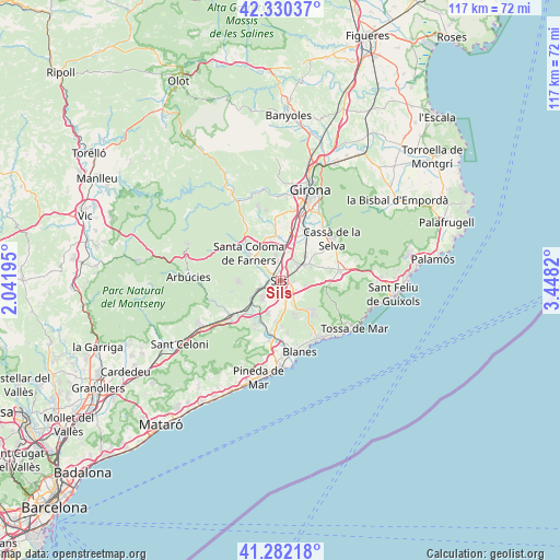
Sils GPS coordinates[2]
41° 48' 30.312" North, 2° 44' 42.252" East
| Map corner | latitude | longitude |
|---|---|---|
| Upper-left | 42.33037°, | 2.04195° |
| Center: | 41.80842°, | 2.74507° |
| Lower-right: | 41.28218°, | 3.4482° |
| Map W x H: | 116.5×116.5 km | = 72.4×72.4mi |
| max Lat: | 43.74134° ⇑31.3% North |
| Sils: | 41.80842° |
| min Lat: | ⇓68.7% South 27.64134° |
| min Long | Sils | max Long |
| -18.00367° | 2.74507° | 4.2899° |
| W 97.4%⇐ | ⇒2.6% E |
Elevation
Elevation of Sils is 79 m = 259 ft, and this is 519 m = 1703 ft below average elevation for this country.
| Max E: |
1682 m = 5518 ft | 89.1% |
| Avg. | 598 m = 1962 ft | |
| Sils | 79 m = 259 ft | |
Min E: |
0 m = 0 ft | 10.9% |
See also: Spain elevation on elevation.city.
Geographical zone
Sils is located in North temperate zone (between Tropic of Cancer and the Arctic Circle). Distance of this Northern Tropic circle is 2042.7 km =1269.3 mi to South.| Distance of | km | miles | from Sils |
|---|---|---|---|
| North Pole | 5358.4 | 3329.6 | to North |
| Arctic Circle | 2752.5 | 1710.3 | to North |
| Tropic Cancer | 2042.7 | 1269.3 | to South |
| Equator | 4648.7 | 2888.6 | to South |


Nearby cities:
15 places around Sils: (largest is in red/bold)
• Aiguaviva
14.5 km =9 mi,  5°
5°
• Brunyola
11.4 km =7.1 mi,  333°
333°
• Caldes de Malavella
6.5 km =4 mi,  64°
64°
• Cassà de la Selva
13.9 km =8.6 mi,  50°
50°
• Hostalric
11.3 km =7 mi,  234°
234°
• Llagostera
12.5 km =7.8 mi,  80°
80°
• Massanes
9 km =5.6 mi,  237°
237°
• Maçanet de la Selva
3 km =1.9 mi,  199°
199°
• Riudarenes
2.5 km =1.6 mi,  291°
291°
• Riudellots de la Selva
10.6 km =6.6 mi,  27°
27°
• Sant Andreu Salou
9.8 km =6.1 mi, 48°
• Santa Coloma de Farners
9.2 km =5.7 mi,  314°
314°
• Tordera
12.3 km =7.6 mi,  190°
190°
• Vidreres
4.2 km =2.6 mi,  131°
131°
• Vilobí d'Onyar
8.3 km =5.2 mi,  2°
2°
Sources, notices
• [Note1] Compared only with cities in Spain existing in our database
• [Src1] Map data: © OpenStreetMap contributors (CC-BY-SA)
• [Src2] Other city data from geonames.org with taken over terms of usage.
• [Src3] Geographical zone / Annual Mean Temperature by Robert A. Rohde @ Wikipedia
