Hijes geodata
Hijes (Castille-La Mancha) is a seat of a third-order administrative division; located in Spain in Europe/Madrid (GMT+2) time zone. With population of 20 people, there are 6726 cities with bigger population in this country. Compared to other cities in Spain, 54.4% of cities are located further ↓South; 54.5% of cities are located further ←West and 95.9% of cities have lower elevation than Hijes. Note1
Administrative division(s):
- Level 1: Castille-La Mancha
- Level 2: Provincia de Guadalajara
- Level 3: Hijes


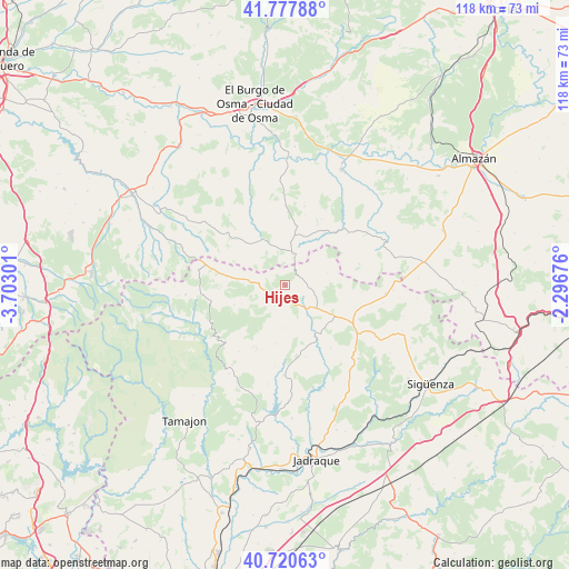
Hijes GPS coordinates[2]
41° 15' 5.004" North, 2° 59' 59.604" West
| Map corner | latitude | longitude |
|---|---|---|
| Upper-left | 41.77788°, | -3.70301° |
| Center: | 41.25139°, | -2.99989° |
| Lower-right: | 40.72063°, | -2.29676° |
| Map W x H: | 117.6×117.6 km | = 73.1×73.1mi |
| max Lat: | 43.74134° ⇑45.6% North |
| Hijes: | 41.25139° |
| min Lat: | ⇓54.4% South 27.64134° |
| min Long | Hijes | max Long |
| -18.00367° | -2.99989° | 4.2899° |
| W 54.5%⇐ | ⇒45.5% E |
Elevation
Elevation of Hijes is 1166 m = 3825 ft, and this is 568 m = 1864 ft above average elevation for this country.
| Max E: |
1682 m = 5518 ft | 4.1% |
| Hijes | 1166 m 3825 ft | |
| Avg. | 598 m = 1962 ft | |
Min E: |
0 m = 0 ft | 95.9% |
See also: Spain elevation on elevation.city.
Geographical zone
Hijes is located in North temperate zone (between Tropic of Cancer and the Arctic Circle). Distance of this Northern Tropic circle is 1980.8 km =1230.8 mi to South.| Distance of | km | miles | from Hijes |
|---|---|---|---|
| North Pole | 5420.3 | 3368 | to North |
| Arctic Circle | 2814.4 | 1748.8 | to North |
| Tropic Cancer | 1980.8 | 1230.8 | to South |
| Equator | 4586.7 | 2850 | to South |


Nearby cities:
15 places around Hijes: (largest is in red/bold)
• Albendiego
5.1 km =3.2 mi,  238°
238°
• Atienza
12.3 km =7.6 mi,  119°
119°
• Bañuelos
8.1 km =5 mi,  61°
61°
• Bustares
14.3 km =8.9 mi,  203°
203°
• Campisábalos
11.3 km =7 mi,  278°
278°
• Condemios de Abajo
9.2 km =5.7 mi,  245°
245°
• Condemios de Arriba
11.2 km =7 mi, 249°
• Gascueña de Bornova
12.2 km =7.6 mi,  187°
187°
• Miedes de Atienza
3.5 km =2.2 mi, 60°
• Prádena de Atienza
8.8 km =5.5 mi,  184°
184°
• Retortillo de Soria
6.8 km =4.2 mi,  12°
12°
• Robledo de Corpes
15.4 km =9.6 mi,  164°
164°
• Romanillos de Atienza
8.5 km =5.3 mi,  78°
78°
• Somolinos
5.1 km =3.2 mi,  263°
263°
• Ujados
1.8 km =1.1 mi, 192°
Sources, notices
• [Note1] Compared only with cities in Spain existing in our database
• [Src1] Map data: © OpenStreetMap contributors (CC-BY-SA)
• [Src2] Other city data from geonames.org with taken over terms of usage.
• [Src3] Geographical zone / Annual Mean Temperature by Robert A. Rohde @ Wikipedia
