Bustares geodata
Bustares (Castille-La Mancha) is a seat of a third-order administrative division; located in Spain in Europe/Madrid (GMT+2) time zone. With population of 98 people, there are 5963 cities with bigger population in this country. Compared to other cities in Spain, 51.7% of cities are located further ↓South; 53.3% of cities are located further ←West and 98% of cities have lower elevation than Bustares. Note1
Administrative division(s):
- Level 1: Castille-La Mancha
- Level 2: Provincia de Guadalajara
- Level 3: Bustares


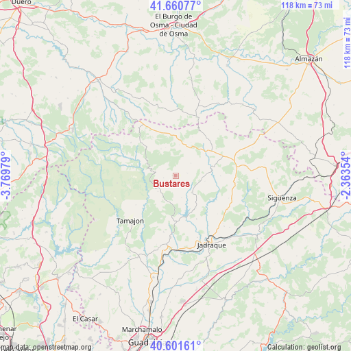
Bustares GPS coordinates[2]
41° 7' 59.988" North, 3° 4' 0.012" West
| Map corner | latitude | longitude |
|---|---|---|
| Upper-left | 41.66077°, | -3.76979° |
| Center: | 41.13333°, | -3.06667° |
| Lower-right: | 40.60161°, | -2.36354° |
| Map W x H: | 117.8×117.8 km | = 73.2×73.2mi |
| max Lat: | 43.74134° ⇑48.3% North |
| Bustares: | 41.13333° |
| min Lat: | ⇓51.7% South 27.64134° |
| min Long | Bustares | max Long |
| -18.00367° | -3.06667° | 4.2899° |
| W 53.3%⇐ | ⇒46.7% E |
Elevation
Elevation of Bustares is 1255 m = 4117 ft, and this is 657 m = 2156 ft above average elevation for this country.
| Max E: |
1682 m = 5518 ft | 2% |
| Bustares | 1255 m 4117 ft | |
| Avg. | 598 m = 1962 ft | |
Min E: |
0 m = 0 ft | 98% |
See also: Spain elevation on elevation.city.
Geographical zone
Bustares is located in North temperate zone (between Tropic of Cancer and the Arctic Circle). Distance of this Northern Tropic circle is 1967.7 km =1222.7 mi to South.| Distance of | km | miles | from Bustares |
|---|---|---|---|
| North Pole | 5433.5 | 3376.2 | to North |
| Arctic Circle | 2827.6 | 1757 | to North |
| Tropic Cancer | 1967.7 | 1222.7 | to South |
| Equator | 4573.6 | 2841.9 | to South |


Nearby cities:
15 places around Bustares: (largest is in red/bold)
• Albendiego
10.5 km =6.5 mi,  6°
6°
• Arroyo de las Fraguas
6.3 km =3.9 mi,  237°
237°
• Condemios de Abajo
9.7 km =6 mi,  343°
343°
• Condemios de Arriba
10.5 km =6.5 mi,  331°
331°
• Congostrina
12.7 km =7.9 mi,  147°
147°
• Galve de Sorbe
13.5 km =8.4 mi,  313°
313°
• Gascueña de Bornova
4.1 km =2.5 mi,  75°
75°
• Hiendelaencina
7.7 km =4.8 mi,  136°
136°
• Prádena de Atienza
6.6 km =4.1 mi,  48°
48°
• Robledo de Corpes
9.9 km =6.2 mi,  99°
99°
• Semillas
9.4 km =5.8 mi,  208°
208°
• Somolinos
12.5 km =7.8 mi,  2°
2°
• Ujados
12.5 km =7.8 mi,  24°
24°
• Villares de Jadraque
4.9 km =3 mi, 135°
• Zarzuela de Jadraque
7.5 km =4.7 mi,  165°
165°
Sources, notices
• [Note1] Compared only with cities in Spain existing in our database
• [Src1] Map data: © OpenStreetMap contributors (CC-BY-SA)
• [Src2] Other city data from geonames.org with taken over terms of usage.
• [Src3] Geographical zone / Annual Mean Temperature by Robert A. Rohde @ Wikipedia
