Eixample geodata
Eixample (Catalonia) is a section of populated place; located in Spain in Europe/Madrid (GMT+2) time zone. With population of 266,477 people, there are 15 cities with bigger population in this country. Compared to other cities in Spain, 57.4% of cities are located further ↓South; 94.5% of cities are located further ←West and 92.1% of cities have higher elevation than Eixample. Note1
Administrative division(s):
- Level 1: Catalonia
- Level 2: Província de Barcelona
- Level 3: Barcelona
- Level 4: Eixample


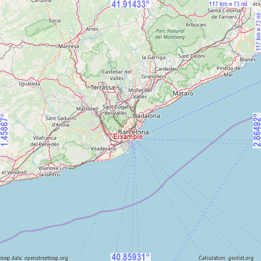
Eixample GPS coordinates[2]
41° 23' 20.256" North, 2° 9' 42.444" East
| Map corner | latitude | longitude |
|---|---|---|
| Upper-left | 41.91433°, | 1.45867° |
| Center: | 41.38896°, | 2.16179° |
| Lower-right: | 40.85931°, | 2.86492° |
| Map W x H: | 117.3×117.3 km | = 72.9×72.9mi |
| max Lat: | 43.74134° ⇑42.6% North |
| Eixample: | 41.38896° |
| min Lat: | ⇓57.4% South 27.64134° |
| min Long | Eixample | max Long |
| -18.00367° | 2.16179° | 4.2899° |
| W 94.5%⇐ | ⇒5.5% E |
Elevation
Elevation of Eixample is 44 m = 144 ft, and this is 554 m = 1818 ft below average elevation for this country.
| Max E: |
1682 m = 5518 ft | 92.1% |
| Avg. | 598 m = 1962 ft | |
| Eixample | 44 m = 144 ft | |
Min E: |
0 m = 0 ft | 7.9% |
See also: Eixample elevation on elevation.city.
Geographical zone
Eixample is located in North temperate zone (between Tropic of Cancer and the Arctic Circle). Distance of this Northern Tropic circle is 1996.1 km =1240.3 mi to South.| Distance of | km | miles | from Eixample |
|---|---|---|---|
| North Pole | 5405 | 3358.5 | to North |
| Arctic Circle | 2799.2 | 1739.3 | to North |
| Tropic Cancer | 1996.1 | 1240.3 | to South |
| Equator | 4602 | 2859.5 | to South |


Nearby cities:
15 places around Eixample: (largest is in red/bold)
• Barcelona
0.2 km =0.1 mi,  265°
265°
• Barri Gòtic
1.3 km =0.8 mi,  116°
116°
• Ciutat Vella
1.4 km =0.9 mi,  135°
135°
• Dreta de l'Eixample
0.9 km =0.6 mi,  28°
28°
• Fort Pienc
1.6 km =1 mi,  67°
67°
• Gràcia
1.6 km =1 mi,  343°
343°
• Poble Sec
1.6 km =1 mi,  175°
175°
• Sagrada Família
1.9 km =1.2 mi, 29°
• Sant Antoni
1.2 km =0.7 mi,  189°
189°
• Sant Gervasi - Galvany
1.8 km =1.1 mi,  301°
301°
• Sant Pere, Santa Caterina i La Ribera
1.7 km =1.1 mi,  106°
106°
• el Raval
1.1 km =0.7 mi,  149°
149°
• l'Antiga Esquerra de l'Eixample
0.6 km =0.4 mi, 274°
• la Nova Esquerra de l'Eixample
1.3 km =0.8 mi,  238°
238°
• la Vila de Gràcia
1.6 km =1 mi,  345°
345°
Sources, notices
• [Note1] Compared only with cities in Spain existing in our database
• [Src1] Map data: © OpenStreetMap contributors (CC-BY-SA)
• [Src2] Other city data from geonames.org with taken over terms of usage.
• [Src3] Geographical zone / Annual Mean Temperature by Robert A. Rohde @ Wikipedia
