Gaztelu geodata
Gaztelu (Basque Country) is a seat of a third-order administrative division; located in Spain in Europe/Madrid (GMT+2) time zone. With population of 151 people, there are 5422 cities with bigger population in this country. Compared to other cities in Spain, 95.4% of cities are located further ↓South; 67.2% of cities are located further ←West and 65.4% of cities have higher elevation than Gaztelu. Note1


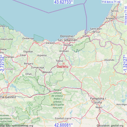
Gaztelu GPS coordinates[2]
43° 6' 58.392" North, 2° 1' 27.804" West
| Map corner | latitude | longitude |
|---|---|---|
| Upper-left | 43.62733°, | -2.72752° |
| Center: | 43.11622°, | -2.02439° |
| Lower-right: | 42.60081°, | -1.32127° |
| Map W x H: | 114.1×114.1 km | = 70.9×70.9mi |
| max Lat: | 43.74134° ⇑4.6% North |
| Gaztelu: | 43.11622° |
| min Lat: | ⇓95.4% South 27.64134° |
| min Long | Gaztelu | max Long |
| -18.00367° | -2.02439° | 4.2899° |
| W 67.2%⇐ | ⇒32.8% E |
Elevation
Elevation of Gaztelu is 455 m = 1493 ft, and this is 143 m = 469 ft below average elevation for this country.
| Max E: |
1682 m = 5518 ft | 65.4% |
| Avg. | 598 m = 1962 ft | |
| Gaztelu | 455 m = 1493 ft | |
Min E: |
0 m = 0 ft | 34.6% |
See also: Spain elevation on elevation.city.
Geographical zone
Gaztelu is located in North temperate zone (between Tropic of Cancer and the Arctic Circle). Distance of this Northern Tropic circle is 2188.2 km =1359.7 mi to South.| Distance of | km | miles | from Gaztelu |
|---|---|---|---|
| North Pole | 5213 | 3239.2 | to North |
| Arctic Circle | 2607.1 | 1620 | to North |
| Tropic Cancer | 2188.2 | 1359.7 | to South |
| Equator | 4794.1 | 2978.9 | to South |


Nearby cities:
15 places around Gaztelu: (largest is in red/bold)
• Alegia
6.1 km =3.8 mi,  253°
253°
• Anoeta
6.4 km =4 mi,  323°
323°
• Areso
7 km =4.3 mi,  122°
122°
• Belauntza
3.1 km =1.9 mi,  314°
314°
• Berastegi
3.7 km =2.3 mi,  76°
76°
• Berrobi
3.2 km =2 mi,  357°
357°
• Elduain
3.3 km =2.1 mi,  35°
35°
• Hernialde
6.5 km =4 mi, 310°
• Ibarra
3.7 km =2.3 mi,  296°
296°
• Irura
6.6 km =4.1 mi,  327°
327°
• Leaburu
2.5 km =1.6 mi,  284°
284°
• Lizartza
1.8 km =1.1 mi,  208°
208°
• Orexa
2.7 km =1.7 mi,  156°
156°
• Tolosa
4.8 km =3 mi, 295°
• Villabona
8 km =5 mi,  343°
343°
Sources, notices
• [Note1] Compared only with cities in Spain existing in our database
• [Src1] Map data: © OpenStreetMap contributors (CC-BY-SA)
• [Src2] Other city data from geonames.org with taken over terms of usage.
• [Src3] Geographical zone / Annual Mean Temperature by Robert A. Rohde @ Wikipedia
