Estercuel geodata
Estercuel (Aragon) is a seat of a third-order administrative division; located in Spain in Europe/Madrid (GMT+2) time zone. With population of 312 people, there are 4455 cities with bigger population in this country. Compared to other cities in Spain, 54.9% of cities are located further ↑North; 80.4% of cities are located further ←West and 73.2% of cities have lower elevation than Estercuel. Note1


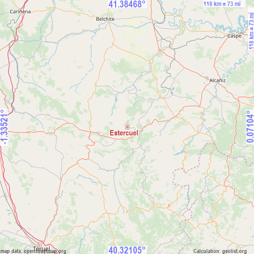
Estercuel GPS coordinates[2]
40° 51' 18" North, 0° 37' 55.488" West
| Map corner | latitude | longitude |
|---|---|---|
| Upper-left | 41.38468°, | -1.33521° |
| Center: | 40.855°, | -0.63208° |
| Lower-right: | 40.32105°, | 0.07104° |
| Map W x H: | 118.3×118.3 km | = 73.5×73.5mi |
| max Lat: | 43.74134° ⇑54.9% North |
| Estercuel: | 40.855° |
| min Lat: | ⇓45.1% South 27.64134° |
| min Long | Estercuel | max Long |
| -18.00367° | -0.63208° | 4.2899° |
| W 80.4%⇐ | ⇒19.6% E |
Elevation
Elevation of Estercuel is 837 m = 2746 ft, and this is 239 m = 784 ft above average elevation for this country.
| Max E: |
1682 m = 5518 ft | 26.8% |
| Estercuel | 837 m 2746 ft | |
| Avg. | 598 m = 1962 ft | |
Min E: |
0 m = 0 ft | 73.2% |
See also: Spain elevation on elevation.city.
Geographical zone
Estercuel is located in North temperate zone (between Tropic of Cancer and the Arctic Circle). Distance of this Northern Tropic circle is 1936.7 km =1203.4 mi to South.| Distance of | km | miles | from Estercuel |
|---|---|---|---|
| North Pole | 5464.4 | 3395.4 | to North |
| Arctic Circle | 2858.5 | 1776.2 | to North |
| Tropic Cancer | 1936.7 | 1203.4 | to South |
| Equator | 4542.7 | 2822.7 | to South |


Nearby cities:
15 places around Estercuel: (largest is in red/bold)
• Alcaine
12.6 km =7.8 mi,  330°
330°
• Alloza
15.4 km =9.6 mi,  34°
34°
• Castel de Cabra
7.9 km =4.9 mi,  222°
222°
• Cañizar del Olivar
4.5 km =2.8 mi,  194°
194°
• Crivillén
5.6 km =3.5 mi,  56°
56°
• Ejulve
11 km =6.8 mi,  142°
142°
• Escucha
16.4 km =10.2 mi,  245°
245°
• Gargallo
4.5 km =2.8 mi,  117°
117°
• Josa
15.9 km =9.9 mi,  314°
314°
• Molinos
15.8 km =9.8 mi,  103°
103°
• Montalbán
14.5 km =9 mi,  260°
260°
• Obón
9.4 km =5.8 mi, 305°
• Oliete
16.3 km =10.1 mi,  347°
347°
• Palomar de Arroyos
13.1 km =8.1 mi,  229°
229°
• Torre de las Arcas
7.4 km =4.6 mi, 258°
Sources, notices
• [Note1] Compared only with cities in Spain existing in our database
• [Src1] Map data: © OpenStreetMap contributors (CC-BY-SA)
• [Src2] Other city data from geonames.org with taken over terms of usage.
• [Src3] Geographical zone / Annual Mean Temperature by Robert A. Rohde @ Wikipedia
