Fortià geodata
Fortià (Catalonia) is a seat of a third-order administrative division; located in Spain in Europe/Madrid (GMT+2) time zone. With population of 558 people, there are 3718 cities with bigger population in this country. Compared to other cities in Spain, 80.4% of cities are located further ↓South; 99% of cities are located further ←West and 99.2% of cities have higher elevation than Fortià. Note1


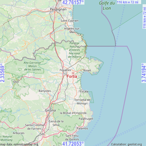
Fortià GPS coordinates[2]
42° 14' 35.52" North, 3° 2' 19.716" East
| Map corner | latitude | longitude |
|---|---|---|
| Upper-left | 42.76157°, | 2.33569° |
| Center: | 42.2432°, | 3.03881° |
| Lower-right: | 41.72053°, | 3.74194° |
| Map W x H: | 115.8×115.8 km | = 72×72mi |
| max Lat: | 43.74134° ⇑19.6% North |
| Fortià: | 42.2432° |
| min Lat: | ⇓80.4% South 27.64134° |
| min Long | Fortià | max Long |
| -18.00367° | 3.03881° | 4.2899° |
| W 99%⇐ | ⇒1% E |
Elevation
Elevation of Fortià is 7 m = 23 ft, and this is 591 m = 1939 ft below average elevation for this country.
| Max E: |
1682 m = 5518 ft | 99.2% |
| Avg. | 598 m = 1962 ft | |
| Fortià | 7 m = 23 ft | |
Min E: |
0 m = 0 ft | 0.8% |
See also: Spain elevation on elevation.city.
Geographical zone
Fortià is located in North temperate zone (between Tropic of Cancer and the Arctic Circle). Distance of this Northern Tropic circle is 2091.1 km =1299.3 mi to South.| Distance of | km | miles | from Fortià |
|---|---|---|---|
| North Pole | 5310.1 | 3299.5 | to North |
| Arctic Circle | 2704.2 | 1680.3 | to North |
| Tropic Cancer | 2091.1 | 1299.3 | to South |
| Equator | 4697 | 2918.6 | to South |


Nearby cities:
15 places around Fortià: (largest is in red/bold)
• Castelló d'Empúries
3.3 km =2.1 mi,  62°
62°
• Empuriabrava
6.7 km =4.2 mi,  86°
86°
• Figueres
6.9 km =4.3 mi,  292°
292°
• Peralada
7.6 km =4.7 mi,  341°
341°
• Riumors
1.8 km =1.1 mi,  171°
171°
• Sant Miquel de Fluvià
8.8 km =5.5 mi,  205°
205°
• Sant Pere Pescador
7.1 km =4.4 mi,  149°
149°
• Siurana
5.3 km =3.3 mi,  224°
224°
• Torroella de Fluvià
7.6 km =4.7 mi,  179°
179°
• Vila-sacra
3 km =1.9 mi,  326°
326°
• Vilabertran
6.4 km =4 mi,  312°
312°
• Vilafant
8.3 km =5.2 mi,  272°
272°
• Vilamacolum
5.4 km =3.4 mi,  164°
164°
• Vilamalla
6.4 km =4 mi,  242°
242°
• l'Armentera
8.5 km =5.3 mi, 159°
Sources, notices
• [Note1] Compared only with cities in Spain existing in our database
• [Src1] Map data: © OpenStreetMap contributors (CC-BY-SA)
• [Src2] Other city data from geonames.org with taken over terms of usage.
• [Src3] Geographical zone / Annual Mean Temperature by Robert A. Rohde @ Wikipedia
