Vilabertran geodata
Vilabertran (Catalonia) is a seat of a third-order administrative division; located in Spain in Europe/Madrid (GMT+2) time zone. With population of 842 people, there are 3144 cities with bigger population in this country. Compared to other cities in Spain, 81.4% of cities are located further ↓South; 98.6% of cities are located further ←West and 95.6% of cities have higher elevation than Vilabertran. Note1


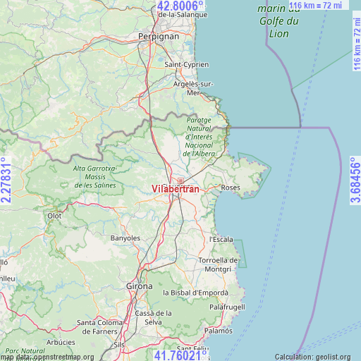
Vilabertran GPS coordinates[2]
42° 16' 57.18" North, 2° 58' 53.184" East
| Map corner | latitude | longitude |
|---|---|---|
| Upper-left | 42.8006°, | 2.27831° |
| Center: | 42.28255°, | 2.98144° |
| Lower-right: | 41.76021°, | 3.68456° |
| Map W x H: | 115.7×115.7 km | = 71.9×71.9mi |
| max Lat: | 43.74134° ⇑18.6% North |
| Vilabertran: | 42.28255° |
| min Lat: | ⇓81.4% South 27.64134° |
| min Long | Vilabertran | max Long |
| -18.00367° | 2.98144° | 4.2899° |
| W 98.6%⇐ | ⇒1.4% E |
Elevation
Elevation of Vilabertran is 22 m = 72 ft, and this is 576 m = 1890 ft below average elevation for this country.
| Max E: |
1682 m = 5518 ft | 95.6% |
| Avg. | 598 m = 1962 ft | |
| Vilabertran | 22 m = 72 ft | |
Min E: |
0 m = 0 ft | 4.4% |
See also: Spain elevation on elevation.city.
Geographical zone
Vilabertran is located in North temperate zone (between Tropic of Cancer and the Arctic Circle). Distance of this Northern Tropic circle is 2095.5 km =1302.1 mi to South.| Distance of | km | miles | from Vilabertran |
|---|---|---|---|
| North Pole | 5305.7 | 3296.8 | to North |
| Arctic Circle | 2699.8 | 1677.6 | to North |
| Tropic Cancer | 2095.5 | 1302.1 | to South |
| Equator | 4701.4 | 2921.3 | to South |


Nearby cities:
15 places around Vilabertran: (largest is in red/bold)
• Avinyonet de Puigventós
6.6 km =4.1 mi,  236°
236°
• Borrassà
8 km =5 mi,  214°
214°
• Cabanes
2.9 km =1.8 mi,  353°
353°
• Castelló d'Empúries
8.2 km =5.1 mi,  110°
110°
• Figueres
2.4 km =1.5 mi,  222°
222°
• Fortià
6.4 km =4 mi,  132°
132°
• Llers
5.9 km =3.7 mi,  284°
284°
• Masarac
7.6 km =4.7 mi, 354°
• Peralada
3.7 km =2.3 mi,  38°
38°
• Pont de Molins
5.5 km =3.4 mi,  309°
309°
• Riumors
7.9 km =4.9 mi,  141°
141°
• Siurana
8.2 km =5.1 mi,  172°
172°
• Vila-sacra
3.6 km =2.2 mi,  121°
121°
• Vilafant
5.3 km =3.3 mi, 221°
• Vilamalla
7.3 km =4.5 mi,  187°
187°
Sources, notices
• [Note1] Compared only with cities in Spain existing in our database
• [Src1] Map data: © OpenStreetMap contributors (CC-BY-SA)
• [Src2] Other city data from geonames.org with taken over terms of usage.
• [Src3] Geographical zone / Annual Mean Temperature by Robert A. Rohde @ Wikipedia
