Fontiveros geodata
Fontiveros (Castille and León) is a seat of a third-order administrative division; located in Spain in Europe/Madrid (GMT+2) time zone. With population of 935 people, there are 3032 cities with bigger population in this country. Compared to other cities in Spain, 53.2% of cities are located further ↑North; 72% of cities are located further →East and 79% of cities have lower elevation than Fontiveros. Note1
Administrative division(s):
- Level 1: Castille and León
- Level 2: Provincia de Ávila
- Level 3: Fontiveros


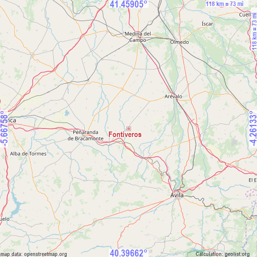
Fontiveros GPS coordinates[2]
40° 55' 47.892" North, 4° 57' 52.02" West
| Map corner | latitude | longitude |
|---|---|---|
| Upper-left | 41.45905°, | -5.66758° |
| Center: | 40.92997°, | -4.96445° |
| Lower-right: | 40.39662°, | -4.26133° |
| Map W x H: | 118.1×118.1 km | = 73.4×73.4mi |
| max Lat: | 43.74134° ⇑53.2% North |
| Fontiveros: | 40.92997° |
| min Lat: | ⇓46.8% South 27.64134° |
| min Long | Fontiveros | max Long |
| -18.00367° | -4.96445° | 4.2899° |
| W 28%⇐ | ⇒72% E |
Elevation
Elevation of Fontiveros is 889 m = 2917 ft, and this is 291 m = 955 ft above average elevation for this country.
| Max E: |
1682 m = 5518 ft | 21% |
| Fontiveros | 889 m 2917 ft | |
| Avg. | 598 m = 1962 ft | |
Min E: |
0 m = 0 ft | 79% |
See also: Spain elevation on elevation.city.
Geographical zone
Fontiveros is located in North temperate zone (between Tropic of Cancer and the Arctic Circle). Distance of this Northern Tropic circle is 1945.1 km =1208.6 mi to South.| Distance of | km | miles | from Fontiveros |
|---|---|---|---|
| North Pole | 5456.1 | 3390.3 | to North |
| Arctic Circle | 2850.2 | 1771 | to North |
| Tropic Cancer | 1945.1 | 1208.6 | to South |
| Equator | 4551 | 2827.9 | to South |


Nearby cities:
15 places around Fontiveros: (largest is in red/bold)
• Cabezas de Alambre
10.4 km =6.5 mi,  82°
82°
• Cabezas del Pozo
8 km =5 mi,  5°
5°
• Canales
9.7 km =6 mi,  32°
32°
• Cantiveros
2.6 km =1.6 mi,  18°
18°
• Cisla
5.8 km =3.6 mi,  314°
314°
• Collado de Contreras
5.5 km =3.4 mi,  149°
149°
• Constanzana
7.6 km =4.7 mi, 83°
• Crespos
6.5 km =4 mi,  184°
184°
• Donjimeno
10.5 km =6.5 mi,  71°
71°
• Flores de Ávila
9.6 km =6 mi,  272°
272°
• Muñomer del Peco
10.6 km =6.6 mi,  138°
138°
• Muñosancho
6.1 km =3.8 mi,  260°
260°
• Narros de Saldueña
10.2 km =6.3 mi,  128°
128°
• Rivilla de Barajas
3.7 km =2.3 mi,  212°
212°
• Viñegra de Moraña
9.5 km =5.9 mi,  157°
157°
Sources, notices
• [Note1] Compared only with cities in Spain existing in our database
• [Src1] Map data: © OpenStreetMap contributors (CC-BY-SA)
• [Src2] Other city data from geonames.org with taken over terms of usage.
• [Src3] Geographical zone / Annual Mean Temperature by Robert A. Rohde @ Wikipedia
