Flores de Ávila geodata
Flores de Ávila (Castille and León) is a seat of a third-order administrative division; located in Spain in Europe/Madrid (GMT+2) time zone. With population of 398 people, there are 4143 cities with bigger population in this country. Compared to other cities in Spain, 53.2% of cities are located further ↑North; 73.5% of cities are located further →East and 80.5% of cities have lower elevation than Flores de Ávila. Note1
Administrative division(s):
- Level 1: Castille and León
- Level 2: Provincia de Ávila
- Level 3: Flores de Ávila


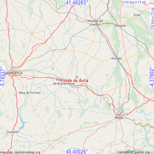
Flores de Ávila GPS coordinates[2]
40° 56' 0.888" North, 5° 4' 44.904" West
| Map corner | latitude | longitude |
|---|---|---|
| Upper-left | 41.46263°, | -5.78227° |
| Center: | 40.93358°, | -5.07914° |
| Lower-right: | 40.40026°, | -4.37602° |
| Map W x H: | 118.1×118.1 km | = 73.4×73.4mi |
| max Lat: | 43.74134° ⇑53.2% North |
| Flores de Ávila: | 40.93358° |
| min Lat: | ⇓46.8% South 27.64134° |
| min Long | Flores de Ávil | max Long |
| -18.00367° | -5.07914° | 4.2899° |
| W 26.5%⇐ | ⇒73.5% E |
Elevation
Elevation of Flores de Ávila is 902 m = 2959 ft, and this is 304 m = 997 ft above average elevation for this country.
| Max E: |
1682 m = 5518 ft | 19.5% |
| Flores de Ávila | 902 m 2959 ft | |
| Avg. | 598 m = 1962 ft | |
Min E: |
0 m = 0 ft | 80.5% |
See also: Spain elevation on elevation.city.
Geographical zone
Flores de Ávila is located in North temperate zone (between Tropic of Cancer and the Arctic Circle). Distance of this Northern Tropic circle is 1945.5 km =1208.9 mi to South.| Distance of | km | miles | from Flores de Ávila |
|---|---|---|---|
| North Pole | 5455.7 | 3390 | to North |
| Arctic Circle | 2849.8 | 1770.8 | to North |
| Tropic Cancer | 1945.5 | 1208.9 | to South |
| Equator | 4551.4 | 2828.1 | to South |


Nearby cities:
15 places around Flores de Ávila: (largest is in red/bold)
• Aldeaseca de la Frontera
10.8 km =6.7 mi,  274°
274°
• Cantaracillo
7.8 km =4.8 mi,  244°
244°
• Cantiveros
10.7 km =6.6 mi,  78°
78°
• Cisla
6.6 km =4.1 mi,  56°
56°
• Fontiveros
9.6 km =6 mi,  92°
92°
• Gimialcón
7.3 km =4.5 mi,  210°
210°
• Mamblas
11.2 km =7 mi,  31°
31°
• Muñosancho
3.9 km =2.4 mi,  110°
110°
• Narros del Castillo
8.5 km =5.3 mi,  169°
169°
• Paradinas de San Juan
8.4 km =5.2 mi,  311°
311°
• Peñaranda de Bracamonte
10.8 km =6.7 mi,  250°
250°
• Rasueros
10 km =6.2 mi,  2°
2°
• Rivilla de Barajas
8.4 km =5.2 mi, 114°
• Rágama
8.2 km =5.1 mi,  330°
330°
• Salvadiós
6.3 km =3.9 mi,  193°
193°
Sources, notices
• [Note1] Compared only with cities in Spain existing in our database
• [Src1] Map data: © OpenStreetMap contributors (CC-BY-SA)
• [Src2] Other city data from geonames.org with taken over terms of usage.
• [Src3] Geographical zone / Annual Mean Temperature by Robert A. Rohde @ Wikipedia
