Fontanar geodata
Fontanar (Castille-La Mancha) is a seat of a third-order administrative division; located in Spain in Europe/Madrid (GMT+2) time zone. With population of 1,393 people, there are 2551 cities with bigger population in this country. Compared to other cities in Spain, 57.5% of cities are located further ↑North; 51.9% of cities are located further ←West and 51.8% of cities have lower elevation than Fontanar. Note1
Administrative division(s):
- Level 1: Castille-La Mancha
- Level 2: Provincia de Guadalajara
- Level 3: Fontanar


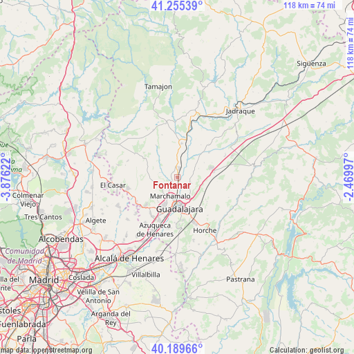
Fontanar GPS coordinates[2]
40° 43' 28.776" North, 3° 10' 23.124" West
| Map corner | latitude | longitude |
|---|---|---|
| Upper-left | 41.25539°, | -3.87622° |
| Center: | 40.72466°, | -3.17309° |
| Lower-right: | 40.18966°, | -2.46997° |
| Map W x H: | 118.5×118.5 km | = 73.6×73.6mi |
| max Lat: | 43.74134° ⇑57.5% North |
| Fontanar: | 40.72466° |
| min Lat: | ⇓42.5% South 27.64134° |
| min Long | Fontanar | max Long |
| -18.00367° | -3.17309° | 4.2899° |
| W 51.9%⇐ | ⇒48.1% E |
Elevation
Elevation of Fontanar is 677 m = 2221 ft, and this is 79 m = 259 ft above average elevation for this country.
| Max E: |
1682 m = 5518 ft | 48.2% |
| Fontanar | 677 m 2221 ft | |
| Avg. | 598 m = 1962 ft | |
Min E: |
0 m = 0 ft | 51.8% |
See also: Spain elevation on elevation.city.
Geographical zone
Fontanar is located in North temperate zone (between Tropic of Cancer and the Arctic Circle). Distance of this Northern Tropic circle is 1922.2 km =1194.4 mi to South.| Distance of | km | miles | from Fontanar |
|---|---|---|---|
| North Pole | 5478.9 | 3404.4 | to North |
| Arctic Circle | 2873 | 1785.2 | to North |
| Tropic Cancer | 1922.2 | 1194.4 | to South |
| Equator | 4528.2 | 2813.7 | to South |


Nearby cities:
15 places around Fontanar: (largest is in red/bold)
• Aldeanueva de Guadalajara
11.9 km =7.4 mi,  114°
114°
• Cabanillas del Campo
11.2 km =7 mi,  205°
205°
• Cañizar
10.4 km =6.5 mi,  62°
62°
• Ciruelas
7.9 km =4.9 mi,  68°
68°
• Fuentelahiguera de Albatages
12.9 km =8 mi,  300°
300°
• Guadalajara
10.7 km =6.6 mi,  174°
174°
• Humanes
11.4 km =7.1 mi,  8°
8°
• Malaguilla
12.6 km =7.8 mi,  326°
326°
• Marchamalo
6.8 km =4.2 mi,  198°
198°
• Mohernando
8.5 km =5.3 mi,  0°
0°
• Málaga del Fresno
9.2 km =5.7 mi,  319°
319°
• Torija
12.4 km =7.7 mi,  80°
80°
• Torre del Burgo
11 km =6.8 mi,  47°
47°
• Tórtola de Henares
4.8 km =3 mi,  118°
118°
• Yunquera de Henares
3.1 km =1.9 mi,  16°
16°
Sources, notices
• [Note1] Compared only with cities in Spain existing in our database
• [Src1] Map data: © OpenStreetMap contributors (CC-BY-SA)
• [Src2] Other city data from geonames.org with taken over terms of usage.
• [Src3] Geographical zone / Annual Mean Temperature by Robert A. Rohde @ Wikipedia
