Humanes geodata
Humanes (Castille-La Mancha) is a seat of a third-order administrative division; located in Spain in Europe/Madrid (GMT+2) time zone. With population of 1,305 people, there are 2639 cities with bigger population in this country. Compared to other cities in Spain, 55.5% of cities are located further ↑North; 52.2% of cities are located further ←West and 60.2% of cities have lower elevation than Humanes. Note1
Administrative division(s):
- Level 1: Castille-La Mancha
- Level 2: Provincia de Guadalajara
- Level 3: Humanes


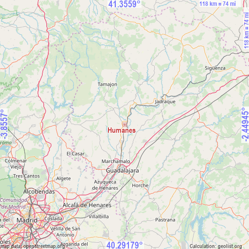
Humanes GPS coordinates[2]
40° 49' 33.528" North, 3° 9' 9.252" West
| Map corner | latitude | longitude |
|---|---|---|
| Upper-left | 41.3559°, | -3.8557° |
| Center: | 40.82598°, | -3.15257° |
| Lower-right: | 40.29179°, | -2.44945° |
| Map W x H: | 118.3×118.3 km | = 73.5×73.5mi |
| max Lat: | 43.74134° ⇑55.5% North |
| Humanes: | 40.82598° |
| min Lat: | ⇓44.5% South 27.64134° |
| min Long | Humanes | max Long |
| -18.00367° | -3.15257° | 4.2899° |
| W 52.2%⇐ | ⇒47.8% E |
Elevation
Elevation of Humanes is 746 m = 2448 ft, and this is 148 m = 486 ft above average elevation for this country.
| Max E: |
1682 m = 5518 ft | 39.8% |
| Humanes | 746 m 2448 ft | |
| Avg. | 598 m = 1962 ft | |
Min E: |
0 m = 0 ft | 60.2% |
See also: Spain elevation on elevation.city.
Geographical zone
Humanes is located in North temperate zone (between Tropic of Cancer and the Arctic Circle). Distance of this Northern Tropic circle is 1933.5 km =1201.4 mi to South.| Distance of | km | miles | from Humanes |
|---|---|---|---|
| North Pole | 5467.6 | 3397.4 | to North |
| Arctic Circle | 2861.8 | 1778.2 | to North |
| Tropic Cancer | 1933.5 | 1201.4 | to South |
| Equator | 4539.4 | 2820.7 | to South |


Nearby cities:
15 places around Humanes: (largest is in red/bold)
• Alarilla
4.8 km =3 mi,  60°
60°
• Cañizar
9.9 km =6.2 mi,  131°
131°
• Ciruelas
10.1 km =6.3 mi,  146°
146°
• Copernal
9.3 km =5.8 mi, 62°
• Espinosa de Henares
10.8 km =6.7 mi,  40°
40°
• Hita
9 km =5.6 mi,  93°
93°
• Malaguilla
8.6 km =5.3 mi,  265°
265°
• Mohernando
3.2 km =2 mi,  211°
211°
• Montarrón
9.5 km =5.9 mi,  19°
19°
• Málaga del Fresno
8.9 km =5.5 mi,  241°
241°
• Puebla de Beleña
8.7 km =5.4 mi,  322°
322°
• Robledillo de Mohernando
7.2 km =4.5 mi,  292°
292°
• Taragudo
6.4 km =4 mi, 94°
• Torre del Burgo
7.4 km =4.6 mi,  120°
120°
• Yunquera de Henares
8.3 km =5.2 mi,  185°
185°
Sources, notices
• [Note1] Compared only with cities in Spain existing in our database
• [Src1] Map data: © OpenStreetMap contributors (CC-BY-SA)
• [Src2] Other city data from geonames.org with taken over terms of usage.
• [Src3] Geographical zone / Annual Mean Temperature by Robert A. Rohde @ Wikipedia
