Fogars de Montclús geodata
Fogars de Montclús (Catalonia) is a seat of a third-order administrative division; located in Spain in Europe/Madrid (GMT+2) time zone. In our database, there are 6762 cities with bigger population. Compared to other cities in Spain, 66.8% of cities are located further ↓South; 96.3% of cities are located further ←West and 59.6% of cities have higher elevation than Fogars de Montclús. Note1
Administrative division(s):
- Level 1: Catalonia
- Level 2: Província de Barcelona
- Level 3: Fogars de Montclús


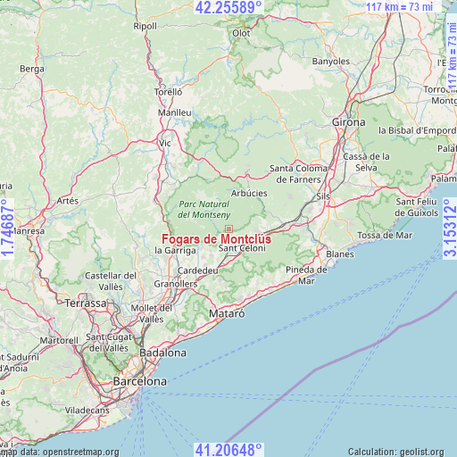
Fogars de Montclús GPS coordinates[2]
41° 43' 59.988" North, 2° 27' 0" East
| Map corner | latitude | longitude |
|---|---|---|
| Upper-left | 42.25589°, | 1.74687° |
| Center: | 41.73333°, | 2.45° |
| Lower-right: | 41.20648°, | 3.15312° |
| Map W x H: | 116.7×116.7 km | = 72.5×72.5mi |
| max Lat: | 43.74134° ⇑33.2% North |
| Fogars de Montclús: | 41.73333° |
| min Lat: | ⇓66.8% South 27.64134° |
| min Long | Fogars de Montc | max Long |
| -18.00367° | 2.45° | 4.2899° |
| W 96.3%⇐ | ⇒3.7% E |
Elevation
Elevation of Fogars de Montclús is 532 m = 1745 ft, and this is 66 m = 217 ft below average elevation for this country.
| Max E: |
1682 m = 5518 ft | 59.6% |
| Avg. | 598 m = 1962 ft | |
| Fogars de Montclús | 532 m = 1745 ft | |
Min E: |
0 m = 0 ft | 40.4% |
See also: Spain elevation on elevation.city.
Geographical zone
Fogars de Montclús is located in North temperate zone (between Tropic of Cancer and the Arctic Circle). Distance of this Northern Tropic circle is 2034.4 km =1264.1 mi to South.| Distance of | km | miles | from Fogars de Montclús |
|---|---|---|---|
| North Pole | 5366.8 | 3334.8 | to North |
| Arctic Circle | 2760.9 | 1715.5 | to North |
| Tropic Cancer | 2034.4 | 1264.1 | to South |
| Equator | 4640.3 | 2883.3 | to South |


Nearby cities:
15 places around Fogars de Montclús: (largest is in red/bold)
• Arbúcies
10.8 km =6.7 mi,  30°
30°
• Breda
9.2 km =5.7 mi,  79°
79°
• Campins
2.3 km =1.4 mi,  143°
143°
• Cardedeu
12.9 km =8 mi,  216°
216°
• Cànoves i Samalús
10 km =6.2 mi,  236°
236°
• Figaró
14.8 km =9.2 mi,  264°
264°
• Gualba de Dalt
4.1 km =2.5 mi,  90°
90°
• Llinars del Vallès
11.9 km =7.4 mi,  200°
200°
• Riells i Viabrea
7.8 km =4.8 mi,  44°
44°
• Sant Celoni
5.9 km =3.7 mi,  146°
146°
• Sant Pere de Vilamajor
7.8 km =4.8 mi, 224°
• Santa Maria de Palautordera
4.4 km =2.7 mi,  184°
184°
• Vallgorguina
10.7 km =6.6 mi, 152°
• Viladrau
13.6 km =8.5 mi,  338°
338°
• la Garriga
14.9 km =9.3 mi,  248°
248°
Sources, notices
• [Note1] Compared only with cities in Spain existing in our database
• [Src1] Map data: © OpenStreetMap contributors (CC-BY-SA)
• [Src2] Other city data from geonames.org with taken over terms of usage.
• [Src3] Geographical zone / Annual Mean Temperature by Robert A. Rohde @ Wikipedia
