Estriégana geodata
Estriégana (Castille-La Mancha) is a seat of a third-order administrative division; located in Spain in Europe/Madrid (GMT+2) time zone. With population of 24 people, there are 6698 cities with bigger population in this country. Compared to other cities in Spain, 50.1% of cities are located further ↑North; 60.7% of cities are located further ←West and 93.6% of cities have lower elevation than Estriégana. Note1
Administrative division(s):
- Level 1: Castille-La Mancha
- Level 2: Provincia de Guadalajara
- Level 3: Estriégana


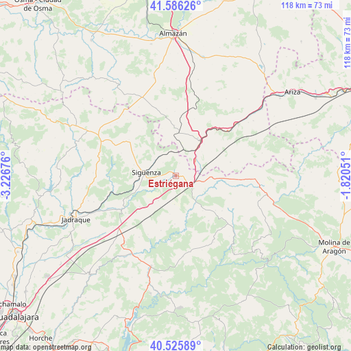
Estriégana GPS coordinates[2]
41° 3' 29.556" North, 2° 31' 25.068" West
| Map corner | latitude | longitude |
|---|---|---|
| Upper-left | 41.58626°, | -3.22676° |
| Center: | 41.05821°, | -2.52363° |
| Lower-right: | 40.52589°, | -1.82051° |
| Map W x H: | 117.9×117.9 km | = 73.3×73.3mi |
| max Lat: | 43.74134° ⇑50.1% North |
| Estriégana: | 41.05821° |
| min Lat: | ⇓49.9% South 27.64134° |
| min Long | Estriégana | max Long |
| -18.00367° | -2.52363° | 4.2899° |
| W 60.7%⇐ | ⇒39.3% E |
Elevation
Elevation of Estriégana is 1107 m = 3632 ft, and this is 509 m = 1670 ft above average elevation for this country.
| Max E: |
1682 m = 5518 ft | 6.4% |
| Estriégana | 1107 m 3632 ft | |
| Avg. | 598 m = 1962 ft | |
Min E: |
0 m = 0 ft | 93.6% |
See also: Spain elevation on elevation.city.
Geographical zone
Estriégana is located in North temperate zone (between Tropic of Cancer and the Arctic Circle). Distance of this Northern Tropic circle is 1959.3 km =1217.5 mi to South.| Distance of | km | miles | from Estriégana |
|---|---|---|---|
| North Pole | 5441.8 | 3381.4 | to North |
| Arctic Circle | 2835.9 | 1762.1 | to North |
| Tropic Cancer | 1959.3 | 1217.5 | to South |
| Equator | 4565.2 | 2836.7 | to South |


Nearby cities:
15 places around Estriégana: (largest is in red/bold)
• Abánades
18.7 km =11.6 mi,  170°
170°
• Alcolea del Pinar
5.4 km =3.4 mi,  117°
117°
• Algora
16 km =9.9 mi,  228°
228°
• Anguita
13.5 km =8.4 mi,  105°
105°
• Iniéstola
14.7 km =9.1 mi, 119°
• Luzaga
11.5 km =7.1 mi,  145°
145°
• Luzón
21 km =13 mi,  99°
99°
• Medinaceli
14.7 km =9.1 mi,  30°
30°
• Saúca
3.1 km =1.9 mi,  188°
188°
• Sienes
19.2 km =11.9 mi,  325°
325°
• Sigüenza
10.1 km =6.3 mi,  276°
276°
• Sotodosos
18.8 km =11.7 mi,  144°
144°
• Torremocha del Campo
12 km =7.5 mi,  221°
221°
• Viana de Jadraque
20.9 km =13 mi,  260°
260°
• Yelo
17.6 km =10.9 mi,  1°
1°
Sources, notices
• [Note1] Compared only with cities in Spain existing in our database
• [Src1] Map data: © OpenStreetMap contributors (CC-BY-SA)
• [Src2] Other city data from geonames.org with taken over terms of usage.
• [Src3] Geographical zone / Annual Mean Temperature by Robert A. Rohde @ Wikipedia
