Sotodosos geodata
Sotodosos (Castille-La Mancha) is a seat of a third-order administrative division; located in Spain in Europe/Madrid (GMT+2) time zone. With population of 67 people, there are 6274 cities with bigger population in this country. Compared to other cities in Spain, 53.4% of cities are located further ↑North; 62.4% of cities are located further ←West and 95.5% of cities have lower elevation than Sotodosos. Note1
Administrative division(s):
- Level 1: Castille-La Mancha
- Level 2: Provincia de Guadalajara
- Level 3: Sotodosos


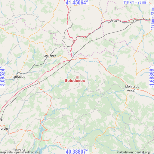
Sotodosos GPS coordinates[2]
40° 55' 17.364" North, 2° 23' 31.596" West
| Map corner | latitude | longitude |
|---|---|---|
| Upper-left | 41.45064°, | -3.09524° |
| Center: | 40.92149°, | -2.39211° |
| Lower-right: | 40.38807°, | -1.68899° |
| Map W x H: | 118.1×118.1 km | = 73.4×73.4mi |
| max Lat: | 43.74134° ⇑53.4% North |
| Sotodosos: | 40.92149° |
| min Lat: | ⇓46.6% South 27.64134° |
| min Long | Sotodosos | max Long |
| -18.00367° | -2.39211° | 4.2899° |
| W 62.4%⇐ | ⇒37.6% E |
Elevation
Elevation of Sotodosos is 1152 m = 3780 ft, and this is 554 m = 1818 ft above average elevation for this country.
| Max E: |
1682 m = 5518 ft | 4.5% |
| Sotodosos | 1152 m 3780 ft | |
| Avg. | 598 m = 1962 ft | |
Min E: |
0 m = 0 ft | 95.5% |
See also: Spain elevation on elevation.city.
Geographical zone
Sotodosos is located in North temperate zone (between Tropic of Cancer and the Arctic Circle). Distance of this Northern Tropic circle is 1944.1 km =1208 mi to South.| Distance of | km | miles | from Sotodosos |
|---|---|---|---|
| North Pole | 5457 | 3390.8 | to North |
| Arctic Circle | 2851.1 | 1771.6 | to North |
| Tropic Cancer | 1944.1 | 1208 | to South |
| Equator | 4550 | 2827.2 | to South |


Nearby cities:
15 places around Sotodosos: (largest is in red/bold)
• Ablanque
14.3 km =8.9 mi,  100°
100°
• Abánades
8.5 km =5.3 mi,  247°
247°
• Alcolea del Pinar
14.1 km =8.8 mi,  333°
333°
• Anguita
11.9 km =7.4 mi,  9°
9°
• Canredondo
14.8 km =9.2 mi,  215°
215°
• Esplegares
7.4 km =4.6 mi,  166°
166°
• Huertahernando
14 km =8.7 mi,  140°
140°
• Iniéstola
8.3 km =5.2 mi, 12°
• Luzaga
7.3 km =4.5 mi,  322°
322°
• Luzón
15.2 km =9.4 mi,  39°
39°
• Ocentejo
16.6 km =10.3 mi,  181°
181°
• Riba de Saelices
8.1 km =5 mi, 97°
• Sacecorbo
10.1 km =6.3 mi,  192°
192°
• Saelices de la Sal
6 km =3.7 mi,  105°
105°
• Torrecuadradilla
14 km =8.7 mi,  237°
237°
Sources, notices
• [Note1] Compared only with cities in Spain existing in our database
• [Src1] Map data: © OpenStreetMap contributors (CC-BY-SA)
• [Src2] Other city data from geonames.org with taken over terms of usage.
• [Src3] Geographical zone / Annual Mean Temperature by Robert A. Rohde @ Wikipedia
