Escalante geodata
Escalante (Cantabria) is a seat of a third-order administrative division; located in Spain in Europe/Madrid (GMT+2) time zone. With population of 763 people, there are 3284 cities with bigger population in this country. Compared to other cities in Spain, 99.1% of cities are located further ↓South; 52.4% of cities are located further →East and 99.2% of cities have higher elevation than Escalante. Note1


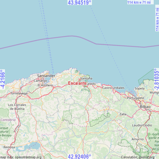
Escalante GPS coordinates[2]
43° 26' 12.408" North, 3° 30' 48.492" West
| Map corner | latitude | longitude |
|---|---|---|
| Upper-left | 43.94519°, | -4.2166° |
| Center: | 43.43678°, | -3.51347° |
| Lower-right: | 42.92406°, | -2.81035° |
| Map W x H: | 113.5×113.5 km | = 70.5×70.5mi |
| max Lat: | 43.74134° ⇑0.9% North |
| Escalante: | 43.43678° |
| min Lat: | ⇓99.1% South 27.64134° |
| min Long | Escalante | max Long |
| -18.00367° | -3.51347° | 4.2899° |
| W 47.6%⇐ | ⇒52.4% E |
Elevation
Elevation of Escalante is 7 m = 23 ft, and this is 591 m = 1939 ft below average elevation for this country.
| Max E: |
1682 m = 5518 ft | 99.2% |
| Avg. | 598 m = 1962 ft | |
| Escalante | 7 m = 23 ft | |
Min E: |
0 m = 0 ft | 0.8% |
See also: Spain elevation on elevation.city.
Geographical zone
Escalante is located in North temperate zone (between Tropic of Cancer and the Arctic Circle). Distance of this Northern Tropic circle is 2223.8 km =1381.8 mi to South.| Distance of | km | miles | from Escalante |
|---|---|---|---|
| North Pole | 5177.3 | 3217 | to North |
| Arctic Circle | 2571.5 | 1597.9 | to North |
| Tropic Cancer | 2223.8 | 1381.8 | to South |
| Equator | 4829.7 | 3001 | to South |


Nearby cities:
15 places around Escalante: (largest is in red/bold)
• Ampuero
13.1 km =8.1 mi,  143°
143°
• Argoños
3 km =1.9 mi,  39°
39°
• Arnuero
6.4 km =4 mi,  315°
315°
• Bareyo
7.8 km =4.8 mi,  295°
295°
• Bárcena de Cicero
1.7 km =1.1 mi,  171°
171°
• Colindres
6.6 km =4.1 mi,  132°
132°
• Entrambasaguas
15 km =9.3 mi,  244°
244°
• Hazas de Cesto
7.6 km =4.7 mi,  233°
233°
• Laredo
8.4 km =5.2 mi,  110°
110°
• Liendo
12.2 km =7.6 mi, 109°
• Limpias
11.2 km =7 mi, 136°
• Noja
5.9 km =3.7 mi,  352°
352°
• San Miguel de Meruelo
6.7 km =4.2 mi,  294°
294°
• Santoña
4.6 km =2.9 mi,  80°
80°
• Solórzano
8.5 km =5.3 mi,  224°
224°
Sources, notices
• [Note1] Compared only with cities in Spain existing in our database
• [Src1] Map data: © OpenStreetMap contributors (CC-BY-SA)
• [Src2] Other city data from geonames.org with taken over terms of usage.
• [Src3] Geographical zone / Annual Mean Temperature by Robert A. Rohde @ Wikipedia
