Argoños geodata
Argoños (Cantabria) is a seat of a third-order administrative division; located in Spain in Europe/Madrid (GMT+2) time zone. With population of 1,380 people, there are 2564 cities with bigger population in this country. Compared to other cities in Spain, 99.2% of cities are located further ↓South; 52% of cities are located further →East and 99.2% of cities have higher elevation than Argoños. Note1


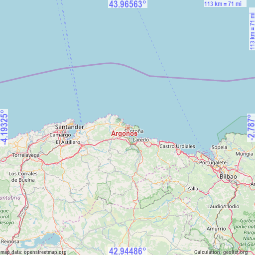
Argoños GPS coordinates[2]
43° 27' 26.64" North, 3° 29' 24.468" West
| Map corner | latitude | longitude |
|---|---|---|
| Upper-left | 43.96563°, | -4.19325° |
| Center: | 43.4574°, | -3.49013° |
| Lower-right: | 42.94486°, | -2.787° |
| Map W x H: | 113.5×113.5 km | = 70.5×70.5mi |
| max Lat: | 43.74134° ⇑0.8% North |
| Argoños: | 43.4574° |
| min Lat: | ⇓99.2% South 27.64134° |
| min Long | Argoños | max Long |
| -18.00367° | -3.49013° | 4.2899° |
| W 48%⇐ | ⇒52% E |
Elevation
Elevation of Argoños is 7 m = 23 ft, and this is 591 m = 1939 ft below average elevation for this country.
| Max E: |
1682 m = 5518 ft | 99.2% |
| Avg. | 598 m = 1962 ft | |
| Argoños | 7 m = 23 ft | |
Min E: |
0 m = 0 ft | 0.8% |
See also: Spain elevation on elevation.city.
Geographical zone
Argoños is located in North temperate zone (between Tropic of Cancer and the Arctic Circle). Distance of this Northern Tropic circle is 2226.1 km =1383.2 mi to South.| Distance of | km | miles | from Argoños |
|---|---|---|---|
| North Pole | 5175.1 | 3215.7 | to North |
| Arctic Circle | 2569.2 | 1596.4 | to North |
| Tropic Cancer | 2226.1 | 1383.2 | to South |
| Equator | 4832 | 3002.5 | to South |


Nearby cities:
15 places around Argoños: (largest is in red/bold)
• Ampuero
14.1 km =8.8 mi,  155°
155°
• Arnuero
6.8 km =4.2 mi,  289°
289°
• Bareyo
9 km =5.6 mi,  276°
276°
• Bárcena de Cicero
4.3 km =2.7 mi,  202°
202°
• Colindres
7.4 km =4.6 mi, 156°
• Escalante
3 km =1.9 mi,  219°
219°
• Hazas de Cesto
10.5 km =6.5 mi,  229°
229°
• Laredo
8 km =5 mi,  131°
131°
• Liendo
11.5 km =7.1 mi,  123°
123°
• Limpias
11.9 km =7.4 mi,  150°
150°
• Noja
4.4 km =2.7 mi,  323°
323°
• Rasines
17.6 km =10.9 mi, 163°
• San Miguel de Meruelo
8 km =5 mi,  273°
273°
• Santoña
3 km =1.9 mi, 119°
• Solórzano
11.5 km =7.1 mi, 223°
Sources, notices
• [Note1] Compared only with cities in Spain existing in our database
• [Src1] Map data: © OpenStreetMap contributors (CC-BY-SA)
• [Src2] Other city data from geonames.org with taken over terms of usage.
• [Src3] Geographical zone / Annual Mean Temperature by Robert A. Rohde @ Wikipedia
