San Miguel de Meruelo geodata
San Miguel de Meruelo (Cantabria) is a populated place; located in Spain in Europe/Madrid (GMT+2) time zone. With population of 1,398 people, there are 2542 cities with bigger population in this country. Compared to other cities in Spain, 99.3% of cities are located further ↓South; 53.5% of cities are located further →East and 98.2% of cities have higher elevation than San Miguel de Meruelo. Note1
Current local time in San Miguel de Meruelo:
11:58 PM, ThursdayDifference from your time zone: hours


San Miguel de Meruelo GPS coordinates[2]
43° 27' 43.596" North, 3° 35' 19.572" West
| Map corner | latitude | longitude |
|---|---|---|
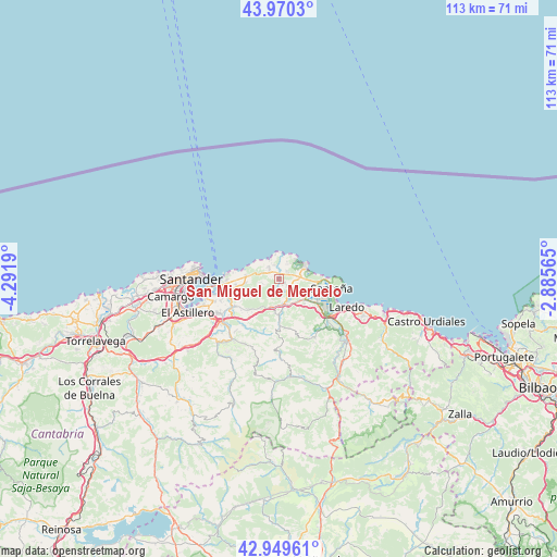
| Upper-left | 43.9703°, | -4.2919° |
| Center: | 43.46211°, | -3.58877° |
| Lower-right: | 42.94961°, | -2.88565° |
| Map W x H: | 113.5×113.5 km | = 70.5×70.5mi |
| max Lat: | 43.74134° ⇑0.7% North |
| San Miguel de Meruelo: | 43.46211° |
| min Lat: | ⇓99.3% South 27.64134° |
| min Long | San Miguel de M | max Long |
| -18.00367° | -3.58877° | 4.2899° |
| W 46.5%⇐ | ⇒53.5% E |
Elevation
Elevation of San Miguel de Meruelo is 11 m = 36 ft, and this is 587 m = 1926 ft below average elevation for this country.
| Max E: |
1682 m = 5518 ft | 98.2% |
| Avg. | 598 m = 1962 ft | |
| San Miguel de Meruelo | 11 m = 36 ft | |
Min E: |
0 m = 0 ft | 1.8% |
See also: Spain elevation on elevation.city.
Geographical zone
San Miguel de Meruelo is located in North temperate zone (between Tropic of Cancer and the Arctic Circle). Distance of this Northern Tropic circle is 2226.6 km =1383.5 mi to South.| Distance of | km | miles | from San Miguel de Meruelo |
|---|---|---|---|
| North Pole | 5174.5 | 3215.3 | to North |
| Arctic Circle | 2568.6 | 1596.1 | to North |
| Tropic Cancer | 2226.6 | 1383.5 | to South |
| Equator | 4832.5 | 3002.8 | to South |


Nearby cities:
15 places around San Miguel de Meruelo: (largest is in red/bold)
• Argoños
8 km =5 mi,  93°
93°
• Arnuero
2.3 km =1.4 mi,  42°
42°
• Bareyo
1.1 km =0.7 mi,  298°
298°
• Bárcena de Cicero
7.8 km =4.8 mi,  125°
125°
• Colindres
13.1 km =8.1 mi,  123°
123°
• Entrambasaguas
11.9 km =7.4 mi,  218°
218°
• Escalante
6.7 km =4.2 mi,  114°
114°
• Hazas de Cesto
7.3 km =4.5 mi,  180°
180°
• Laredo
15.1 km =9.4 mi, 112°
• Limpias
17.6 km =10.9 mi, 128°
• Liérganes
18.1 km =11.2 mi, 224°
• Noja
6.1 km =3.8 mi,  60°
60°
• Santander
17.4 km =10.8 mi,  270°
270°
• Santoña
10.8 km =6.7 mi,  100°
100°
• Solórzano
8.9 km =5.5 mi, 179°
Sources, notices
• [Note1] Compared only with cities in Spain existing in our database
• [Src1] Map data: © OpenStreetMap contributors (CC-BY-SA)
• [Src2] Other city data from geonames.org with taken over terms of usage.
• [Src3] Geographical zone / Annual Mean Temperature by Robert A. Rohde @ Wikipedia
