Erla geodata
Erla (Aragon) is a seat of a third-order administrative division; located in Spain in Europe/Madrid (GMT+2) time zone. With population of 432 people, there are 4048 cities with bigger population in this country. Compared to other cities in Spain, 77% of cities are located further ↓South; 77.6% of cities are located further ←West and 67.4% of cities have higher elevation than Erla. Note1


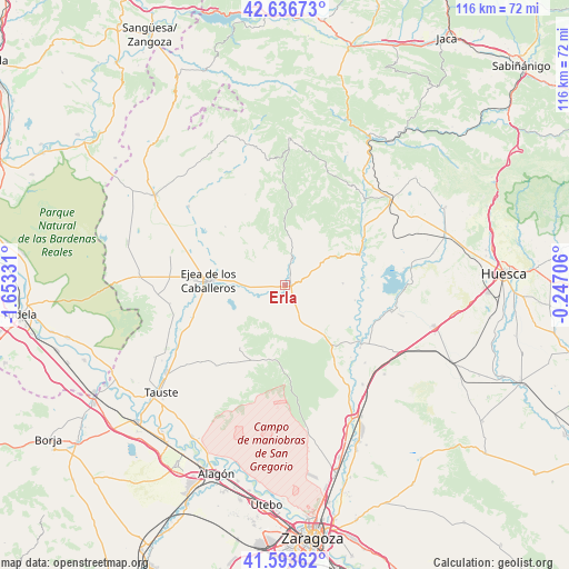
Erla GPS coordinates[2]
42° 7' 2.352" North, 0° 57' 0.684" West
| Map corner | latitude | longitude |
|---|---|---|
| Upper-left | 42.63673°, | -1.65331° |
| Center: | 42.11732°, | -0.95019° |
| Lower-right: | 41.59362°, | -0.24706° |
| Map W x H: | 116×116 km | = 72.1×72.1mi |
| max Lat: | 43.74134° ⇑23% North |
| Erla: | 42.11732° |
| min Lat: | ⇓77% South 27.64134° |
| min Long | Erla | max Long |
| -18.00367° | -0.95019° | 4.2899° |
| W 77.6%⇐ | ⇒22.4% E |
Elevation
Elevation of Erla is 427 m = 1401 ft, and this is 171 m = 561 ft below average elevation for this country.
| Max E: |
1682 m = 5518 ft | 67.4% |
| Avg. | 598 m = 1962 ft | |
| Erla | 427 m = 1401 ft | |
Min E: |
0 m = 0 ft | 32.6% |
See also: Spain elevation on elevation.city.
Geographical zone
Erla is located in North temperate zone (between Tropic of Cancer and the Arctic Circle). Distance of this Northern Tropic circle is 2077.1 km =1290.6 mi to South.| Distance of | km | miles | from Erla |
|---|---|---|---|
| North Pole | 5324.1 | 3308.2 | to North |
| Arctic Circle | 2718.2 | 1689 | to North |
| Tropic Cancer | 2077.1 | 1290.6 | to South |
| Equator | 4683 | 2909.9 | to South |


Nearby cities:
15 places around Erla: (largest is in red/bold)
• Alcalá de Gurrea
22.6 km =14 mi,  104°
104°
• Asin
20.1 km =12.5 mi,  336°
336°
• Biota
25.3 km =15.7 mi,  309°
309°
• Biscarrués
20.6 km =12.8 mi,  53°
53°
• Castejón de Valdejasa
15.5 km =9.6 mi,  193°
193°
• Ejea de los Caballeros
15.5 km =9.6 mi,  273°
273°
• Gurrea de Gállego
19.3 km =12 mi,  126°
126°
• Luna
5.8 km =3.6 mi,  14°
14°
• Marracos
14.7 km =9.1 mi, 102°
• Ontinar de Salz
25.8 km =16 mi,  141°
141°
• Orés
18.3 km =11.4 mi,  346°
346°
• Piedratajada
12.1 km =7.5 mi,  87°
87°
• Santa Eulalia de Gállego
24.5 km =15.2 mi,  39°
39°
• Sierra de Luna
8.4 km =5.2 mi,  156°
156°
• Valpalmas
9.1 km =5.7 mi,  59°
59°
Sources, notices
• [Note1] Compared only with cities in Spain existing in our database
• [Src1] Map data: © OpenStreetMap contributors (CC-BY-SA)
• [Src2] Other city data from geonames.org with taken over terms of usage.
• [Src3] Geographical zone / Annual Mean Temperature by Robert A. Rohde @ Wikipedia
