Biscarrués geodata
Biscarrués (Aragon) is a seat of a third-order administrative division; located in Spain in Europe/Madrid (GMT+2) time zone. With population of 233 people, there are 4843 cities with bigger population in this country. Compared to other cities in Spain, 80% of cities are located further ↓South; 79.5% of cities are located further ←West and 64.6% of cities have higher elevation than Biscarrués. Note1


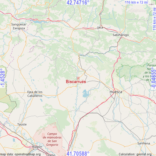
Biscarrués GPS coordinates[2]
42° 13' 43.212" North, 0° 44' 58.812" West
| Map corner | latitude | longitude |
|---|---|---|
| Upper-left | 42.74716°, | -1.4528° |
| Center: | 42.22867°, | -0.74967° |
| Lower-right: | 41.70588°, | -0.04655° |
| Map W x H: | 115.8×115.8 km | = 72×72mi |
| max Lat: | 43.74134° ⇑20% North |
| Biscarrués: | 42.22867° |
| min Lat: | ⇓80% South 27.64134° |
| min Long | Biscarrués | max Long |
| -18.00367° | -0.74967° | 4.2899° |
| W 79.5%⇐ | ⇒20.5% E |
Elevation
Elevation of Biscarrués is 465 m = 1526 ft, and this is 133 m = 436 ft below average elevation for this country.
| Max E: |
1682 m = 5518 ft | 64.6% |
| Avg. | 598 m = 1962 ft | |
| Biscarrués | 465 m = 1526 ft | |
Min E: |
0 m = 0 ft | 35.4% |
See also: Spain elevation on elevation.city.
Geographical zone
Biscarrués is located in North temperate zone (between Tropic of Cancer and the Arctic Circle). Distance of this Northern Tropic circle is 2089.5 km =1298.4 mi to South.| Distance of | km | miles | from Biscarrués |
|---|---|---|---|
| North Pole | 5311.7 | 3300.5 | to North |
| Arctic Circle | 2705.8 | 1681.3 | to North |
| Tropic Cancer | 2089.5 | 1298.4 | to South |
| Equator | 4695.4 | 2917.6 | to South |


Nearby cities:
15 places around Biscarrués: (largest is in red/bold)
• Agüero
14.5 km =9 mi,  345°
345°
• Alcalá de Gurrea
18.8 km =11.7 mi,  163°
163°
• Ayerbe
7 km =4.3 mi,  45°
45°
• Biel
23.7 km =14.7 mi,  318°
318°
• Erla
20.6 km =12.8 mi,  233°
233°
• Gurrea de Gállego
23.7 km =14.7 mi,  182°
182°
• Loarre
13.9 km =8.6 mi, 46°
• Loscorrales
9.2 km =5.7 mi,  71°
71°
• Luna
16.6 km =10.3 mi,  245°
245°
• Marracos
15.8 km =9.8 mi,  187°
187°
• Orés
21.4 km =13.3 mi,  284°
284°
• Piedratajada
12.7 km =7.9 mi,  200°
200°
• Santa Eulalia de Gállego
6.5 km =4 mi, 352°
• Sierra de Luna
24 km =14.9 mi,  213°
213°
• Valpalmas
11.7 km =7.3 mi, 227°
Sources, notices
• [Note1] Compared only with cities in Spain existing in our database
• [Src1] Map data: © OpenStreetMap contributors (CC-BY-SA)
• [Src2] Other city data from geonames.org with taken over terms of usage.
• [Src3] Geographical zone / Annual Mean Temperature by Robert A. Rohde @ Wikipedia
