Cuadros geodata
Cuadros (Castille and León) is a seat of a third-order administrative division; located in Spain in Europe/Madrid (GMT+2) time zone. With population of 1,810 people, there are 2282 cities with bigger population in this country. Compared to other cities in Spain, 91.6% of cities are located further ↓South; 80.7% of cities are located further →East and 80.4% of cities have lower elevation than Cuadros. Note1


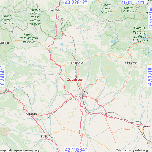
Cuadros GPS coordinates[2]
42° 42' 41.868" North, 5° 38' 17.808" West
| Map corner | latitude | longitude |
|---|---|---|
| Upper-left | 43.22612°, | -6.34141° |
| Center: | 42.71163°, | -5.63828° |
| Lower-right: | 42.19284°, | -4.93516° |
| Map W x H: | 114.9×114.9 km | = 71.4×71.4mi |
| max Lat: | 43.74134° ⇑8.4% North |
| Cuadros: | 42.71163° |
| min Lat: | ⇓91.6% South 27.64134° |
| min Long | Cuadros | max Long |
| -18.00367° | -5.63828° | 4.2899° |
| W 19.3%⇐ | ⇒80.7% E |
Elevation
Elevation of Cuadros is 901 m = 2956 ft, and this is 303 m = 994 ft above average elevation for this country.
| Max E: |
1682 m = 5518 ft | 19.6% |
| Cuadros | 901 m 2956 ft | |
| Avg. | 598 m = 1962 ft | |
Min E: |
0 m = 0 ft | 80.4% |
See also: Spain elevation on elevation.city.
Geographical zone
Cuadros is located in North temperate zone (between Tropic of Cancer and the Arctic Circle). Distance of this Northern Tropic circle is 2143.2 km =1331.7 mi to South.| Distance of | km | miles | from Cuadros |
|---|---|---|---|
| North Pole | 5258 | 3267.2 | to North |
| Arctic Circle | 2652.1 | 1647.9 | to North |
| Tropic Cancer | 2143.2 | 1331.7 | to South |
| Equator | 4749.1 | 2951 | to South |


Nearby cities:
15 places around Cuadros: (largest is in red/bold)
• Carrocera
12.7 km =7.9 mi,  317°
317°
• Cimanes del Tejar
17.2 km =10.7 mi,  232°
232°
• Garrafe de Torío
9.7 km =6 mi,  75°
75°
• La Pola de Gordón
16.3 km =10.1 mi,  351°
351°
• La Robla
10.2 km =6.3 mi,  4°
4°
• León
13.6 km =8.5 mi,  155°
155°
• Llamas de la Ribera
17.5 km =10.9 mi,  240°
240°
• Matallana de Torío
19.6 km =12.2 mi,  29°
29°
• San Andrés del Rabanedo
11.2 km =7 mi,  170°
170°
• Santa Colomba de Curueño
19 km =11.8 mi, 76°
• Santa María de Ordás
15.2 km =9.4 mi,  276°
276°
• Sariegos
6.9 km =4.3 mi,  176°
176°
• Valdefresno
17.6 km =10.9 mi,  137°
137°
• Valverde de la Virgen
16.4 km =10.2 mi,  193°
193°
• Villaquilambre
9.7 km =6 mi, 137°
Sources, notices
• [Note1] Compared only with cities in Spain existing in our database
• [Src1] Map data: © OpenStreetMap contributors (CC-BY-SA)
• [Src2] Other city data from geonames.org with taken over terms of usage.
• [Src3] Geographical zone / Annual Mean Temperature by Robert A. Rohde @ Wikipedia
