Garrafe de Torío geodata
Garrafe de Torío (Castille and León) is a seat of a third-order administrative division; located in Spain in Europe/Madrid (GMT+2) time zone. With population of 1,101 people, there are 2822 cities with bigger population in this country. Compared to other cities in Spain, 91.9% of cities are located further ↓South; 79% of cities are located further →East and 81.9% of cities have lower elevation than Garrafe de Torío. Note1
Administrative division(s):
- Level 1: Castille and León
- Level 2: Provincia de León
- Level 3: Garrafe de Torío


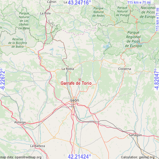
Garrafe de Torío GPS coordinates[2]
42° 43' 58.26" North, 5° 31' 24.96" West
| Map corner | latitude | longitude |
|---|---|---|
| Upper-left | 43.24716°, | -6.22672° |
| Center: | 42.73285°, | -5.5236° |
| Lower-right: | 42.21424°, | -4.82047° |
| Map W x H: | 114.8×114.8 km | = 71.3×71.3mi |
| max Lat: | 43.74134° ⇑8.1% North |
| Garrafe de Torío: | 42.73285° |
| min Lat: | ⇓91.9% South 27.64134° |
| min Long | Garrafe de Tor� | max Long |
| -18.00367° | -5.5236° | 4.2899° |
| W 21%⇐ | ⇒79% E |
Elevation
Elevation of Garrafe de Torío is 916 m = 3005 ft, and this is 318 m = 1043 ft above average elevation for this country.
| Max E: |
1682 m = 5518 ft | 18.1% |
| Garrafe de Torío | 916 m 3005 ft | |
| Avg. | 598 m = 1962 ft | |
Min E: |
0 m = 0 ft | 81.9% |
See also: Spain elevation on elevation.city.
Geographical zone
Garrafe de Torío is located in North temperate zone (between Tropic of Cancer and the Arctic Circle). Distance of this Northern Tropic circle is 2145.5 km =1333.2 mi to South.| Distance of | km | miles | from Garrafe de Torío |
|---|---|---|---|
| North Pole | 5255.6 | 3265.7 | to North |
| Arctic Circle | 2649.7 | 1646.4 | to North |
| Tropic Cancer | 2145.5 | 1333.2 | to South |
| Equator | 4751.4 | 2952.4 | to South |


Nearby cities:
15 places around Garrafe de Torío: (largest is in red/bold)
• Boñar
22.1 km =13.7 mi,  47°
47°
• Carrocera
19.3 km =12 mi,  291°
291°
• Cuadros
9.7 km =6 mi,  255°
255°
• La Pola de Gordón
18.1 km =11.2 mi,  319°
319°
• La Robla
11.6 km =7.2 mi,  312°
312°
• León
15.3 km =9.5 mi,  194°
194°
• Matallana de Torío
14.8 km =9.2 mi,  1°
1°
• San Andrés del Rabanedo
15.5 km =9.6 mi,  209°
209°
• Santa Colomba de Curueño
9.3 km =5.8 mi,  77°
77°
• Sariegos
12.9 km =8 mi,  224°
224°
• Valdefresno
15.5 km =9.6 mi,  170°
170°
• Valdepiélago
18.3 km =11.4 mi,  34°
34°
• Vegacervera
17.3 km =10.7 mi,  356°
356°
• Vegaquemada
18.3 km =11.4 mi,  58°
58°
• Villaquilambre
10 km =6.2 mi,  196°
196°
Sources, notices
• [Note1] Compared only with cities in Spain existing in our database
• [Src1] Map data: © OpenStreetMap contributors (CC-BY-SA)
• [Src2] Other city data from geonames.org with taken over terms of usage.
• [Src3] Geographical zone / Annual Mean Temperature by Robert A. Rohde @ Wikipedia
