La Robla geodata
La Robla (Castille and León) is a populated place; located in Spain in Europe/Madrid (GMT+2) time zone. With population of 4,656 people, there are 1364 cities with bigger population in this country. Compared to other cities in Spain, 92.7% of cities are located further ↓South; 80.6% of cities are located further →East and 85.4% of cities have lower elevation than La Robla. Note1
Administrative division(s):
- Level 1: Castille and León
- Level 2: Provincia de León
- Level 3: Robla, La


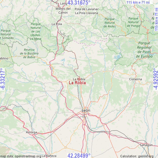
La Robla GPS coordinates[2]
42° 48' 10.872" North, 5° 37' 44.544" West
| Map corner | latitude | longitude |
|---|---|---|
| Upper-left | 43.31675°, | -6.33217° |
| Center: | 42.80302°, | -5.62904° |
| Lower-right: | 42.28499°, | -4.92592° |
| Map W x H: | 114.7×114.7 km | = 71.3×71.3mi |
| max Lat: | 43.74134° ⇑7.3% North |
| La Robla: | 42.80302° |
| min Lat: | ⇓92.7% South 27.64134° |
| min Long | La Robla | max Long |
| -18.00367° | -5.62904° | 4.2899° |
| W 19.4%⇐ | ⇒80.6% E |
Elevation
Elevation of La Robla is 955 m = 3133 ft, and this is 357 m = 1171 ft above average elevation for this country.
| Max E: |
1682 m = 5518 ft | 14.6% |
| La Robla | 955 m 3133 ft | |
| Avg. | 598 m = 1962 ft | |
Min E: |
0 m = 0 ft | 85.4% |
See also: Spain elevation on elevation.city.
Geographical zone
La Robla is located in North temperate zone (between Tropic of Cancer and the Arctic Circle). Distance of this Northern Tropic circle is 2153.3 km =1338 mi to South.| Distance of | km | miles | from La Robla |
|---|---|---|---|
| North Pole | 5247.8 | 3260.8 | to North |
| Arctic Circle | 2641.9 | 1641.6 | to North |
| Tropic Cancer | 2153.3 | 1338 | to South |
| Equator | 4759.2 | 2957.2 | to South |


Nearby cities:
15 places around La Robla: (largest is in red/bold)
• Carrocera
9.4 km =5.8 mi,  265°
265°
• Cuadros
10.2 km =6.3 mi,  184°
184°
• Cármenes
17.9 km =11.1 mi,  14°
14°
• Garrafe de Torío
11.6 km =7.2 mi,  132°
132°
• La Pola de Gordón
6.7 km =4.2 mi,  332°
332°
• Matallana de Torío
11.3 km =7 mi,  51°
51°
• San Andrés del Rabanedo
21.3 km =13.2 mi, 177°
• Santa Colomba de Curueño
18.6 km =11.6 mi,  108°
108°
• Santa María de Ordás
18 km =11.2 mi,  241°
241°
• Sariegos
17 km =10.6 mi, 181°
• Soto y Amío
21.3 km =13.2 mi,  261°
261°
• Valdepiélago
20.2 km =12.6 mi,  68°
68°
• Vegacervera
12.1 km =7.5 mi,  38°
38°
• Villamanín
15.2 km =9.4 mi,  351°
351°
• Villaquilambre
18.3 km =11.4 mi,  161°
161°
Sources, notices
• [Note1] Compared only with cities in Spain existing in our database
• [Src1] Map data: © OpenStreetMap contributors (CC-BY-SA)
• [Src2] Other city data from geonames.org with taken over terms of usage.
• [Src3] Geographical zone / Annual Mean Temperature by Robert A. Rohde @ Wikipedia
