Cistella geodata
Cistella (Catalonia) is a seat of a third-order administrative division; located in Spain in Europe/Madrid (GMT+2) time zone. With population of 233 people, there are 4843 cities with bigger population in this country. Compared to other cities in Spain, 81.1% of cities are located further ↓South; 97.9% of cities are located further ←West and 85.6% of cities have higher elevation than Cistella. Note1


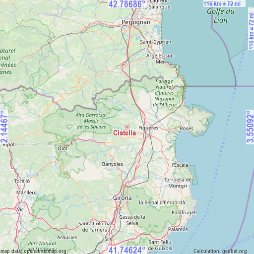
Cistella GPS coordinates[2]
42° 16' 7.32" North, 2° 50' 52.08" East
| Map corner | latitude | longitude |
|---|---|---|
| Upper-left | 42.78686°, | 2.14467° |
| Center: | 42.2687°, | 2.8478° |
| Lower-right: | 41.74624°, | 3.55092° |
| Map W x H: | 115.7×115.7 km | = 71.9×71.9mi |
| max Lat: | 43.74134° ⇑18.9% North |
| Cistella: | 42.2687° |
| min Lat: | ⇓81.1% South 27.64134° |
| min Long | Cistella | max Long |
| -18.00367° | 2.8478° | 4.2899° |
| W 97.9%⇐ | ⇒2.1% E |
Elevation
Elevation of Cistella is 130 m = 427 ft, and this is 468 m = 1535 ft below average elevation for this country.
| Max E: |
1682 m = 5518 ft | 85.6% |
| Avg. | 598 m = 1962 ft | |
| Cistella | 130 m = 427 ft | |
Min E: |
0 m = 0 ft | 14.4% |
See also: Spain elevation on elevation.city.
Geographical zone
Cistella is located in North temperate zone (between Tropic of Cancer and the Arctic Circle). Distance of this Northern Tropic circle is 2093.9 km =1301.1 mi to South.| Distance of | km | miles | from Cistella |
|---|---|---|---|
| North Pole | 5307.2 | 3297.7 | to North |
| Arctic Circle | 2701.3 | 1678.5 | to North |
| Tropic Cancer | 2093.9 | 1301.1 | to South |
| Equator | 4699.8 | 2920.3 | to South |


Nearby cities:
15 places around Cistella: (largest is in red/bold)
• Avinyonet de Puigventós
5.9 km =3.7 mi,  110°
110°
• Biure
8.6 km =5.3 mi,  27°
27°
• Borrassà
8.2 km =5.1 mi,  128°
128°
• Cabanelles
4.8 km =3 mi,  208°
208°
• Crespià
10.3 km =6.4 mi,  202°
202°
• Figueres
9.4 km =5.8 mi,  91°
91°
• Lladó
3.6 km =2.2 mi,  230°
230°
• Llers
6.1 km =3.8 mi,  60°
60°
• Navata
5.1 km =3.2 mi,  167°
167°
• Ordis
7.4 km =4.6 mi,  138°
138°
• Pont de Molins
8.5 km =5.3 mi,  53°
53°
• Sant Llorenç de la Muga
7.5 km =4.7 mi,  319°
319°
• Terrades
4.7 km =2.9 mi,  350°
350°
• Vilafant
7.8 km =4.8 mi, 108°
• Vilanant
3.7 km =2.3 mi, 114°
Sources, notices
• [Note1] Compared only with cities in Spain existing in our database
• [Src1] Map data: © OpenStreetMap contributors (CC-BY-SA)
• [Src2] Other city data from geonames.org with taken over terms of usage.
• [Src3] Geographical zone / Annual Mean Temperature by Robert A. Rohde @ Wikipedia
