Borrassà geodata
Borrassà (Catalonia) is a seat of a third-order administrative division; located in Spain in Europe/Madrid (GMT+2) time zone. With population of 581 people, there are 3656 cities with bigger population in this country. Compared to other cities in Spain, 79.9% of cities are located further ↓South; 98.3% of cities are located further ←West and 89.5% of cities have higher elevation than Borrassà. Note1


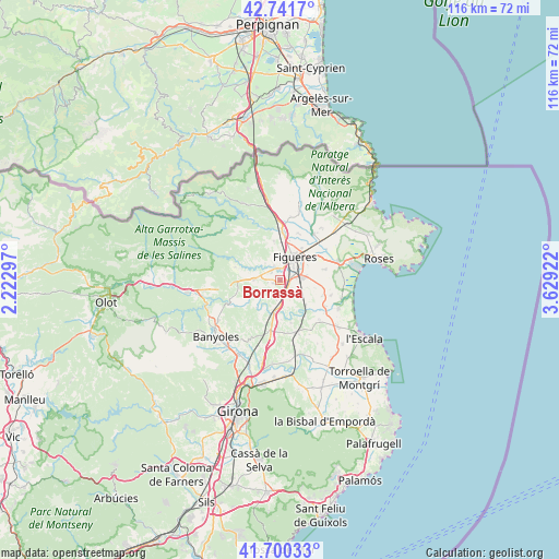
Borrassà GPS coordinates[2]
42° 13' 23.376" North, 2° 55' 33.96" East
| Map corner | latitude | longitude |
|---|---|---|
| Upper-left | 42.7417°, | 2.22297° |
| Center: | 42.22316°, | 2.9261° |
| Lower-right: | 41.70033°, | 3.62922° |
| Map W x H: | 115.8×115.8 km | = 72×72mi |
| max Lat: | 43.74134° ⇑20.1% North |
| Borrassà: | 42.22316° |
| min Lat: | ⇓79.9% South 27.64134° |
| min Long | Borrassà | max Long |
| -18.00367° | 2.9261° | 4.2899° |
| W 98.3%⇐ | ⇒1.7% E |
Elevation
Elevation of Borrassà is 75 m = 246 ft, and this is 523 m = 1716 ft below average elevation for this country.
| Max E: |
1682 m = 5518 ft | 89.5% |
| Avg. | 598 m = 1962 ft | |
| Borrassà | 75 m = 246 ft | |
Min E: |
0 m = 0 ft | 10.5% |
See also: Spain elevation on elevation.city.
Geographical zone
Borrassà is located in North temperate zone (between Tropic of Cancer and the Arctic Circle). Distance of this Northern Tropic circle is 2088.9 km =1298 mi to South.| Distance of | km | miles | from Borrassà |
|---|---|---|---|
| North Pole | 5312.3 | 3300.9 | to North |
| Arctic Circle | 2706.4 | 1681.7 | to North |
| Tropic Cancer | 2088.9 | 1298 | to South |
| Equator | 4694.8 | 2917.2 | to South |


Nearby cities:
15 places around Borrassà: (largest is in red/bold)
• Avinyonet de Puigventós
3.1 km =1.9 mi,  343°
343°
• Bàscara
7.1 km =4.4 mi,  190°
190°
• Cistella
8.2 km =5.1 mi,  308°
308°
• Figueres
5.6 km =3.5 mi,  31°
31°
• Garrigàs
4 km =2.5 mi,  144°
144°
• Llers
8.2 km =5.1 mi,  351°
351°
• Navata
5.4 km =3.4 mi,  270°
270°
• Ordis
1.7 km =1.1 mi,  250°
250°
• Pontós
4.1 km =2.5 mi, 190°
• Sant Miquel de Fluvià
7.9 km =4.9 mi, 136°
• Siurana
5.8 km =3.6 mi,  105°
105°
• Vilabertran
8 km =5 mi, 34°
• Vilafant
2.8 km =1.7 mi,  20°
20°
• Vilamalla
3.7 km =2.3 mi,  100°
100°
• Vilanant
4.6 km =2.9 mi,  319°
319°
Sources, notices
• [Note1] Compared only with cities in Spain existing in our database
• [Src1] Map data: © OpenStreetMap contributors (CC-BY-SA)
• [Src2] Other city data from geonames.org with taken over terms of usage.
• [Src3] Geographical zone / Annual Mean Temperature by Robert A. Rohde @ Wikipedia
