Cesuras geodata
Cesuras (Galicia) is a populated place; located in Spain in Europe/Madrid (GMT+2) time zone. With population of 2,422 people, there are 1932 cities with bigger population in this country. Compared to other cities in Spain, 96.1% of cities are located further ↓South; 96.8% of cities are located further →East and 73.1% of cities have higher elevation than Cesuras. Note1


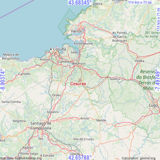
Cesuras GPS coordinates[2]
43° 10' 22.152" North, 8° 12' 2.196" West
| Map corner | latitude | longitude |
|---|---|---|
| Upper-left | 43.68345°, | -8.90374° |
| Center: | 43.17282°, | -8.20061° |
| Lower-right: | 42.65788°, | -7.49749° |
| Map W x H: | 114×114 km | = 70.8×70.8mi |
| max Lat: | 43.74134° ⇑3.9% North |
| Cesuras: | 43.17282° |
| min Lat: | ⇓96.1% South 27.64134° |
| min Long | Cesuras | max Long |
| -18.00367° | -8.20061° | 4.2899° |
| W 3.2%⇐ | ⇒96.8% E |
Elevation
Elevation of Cesuras is 329 m = 1079 ft, and this is 269 m = 883 ft below average elevation for this country.
| Max E: |
1682 m = 5518 ft | 73.1% |
| Avg. | 598 m = 1962 ft | |
| Cesuras | 329 m = 1079 ft | |
Min E: |
0 m = 0 ft | 26.9% |
See also: Spain elevation on elevation.city.
Geographical zone
Cesuras is located in North temperate zone (between Tropic of Cancer and the Arctic Circle). Distance of this Northern Tropic circle is 2194.4 km =1363.5 mi to South.| Distance of | km | miles | from Cesuras |
|---|---|---|---|
| North Pole | 5206.7 | 3235.3 | to North |
| Arctic Circle | 2600.8 | 1616.1 | to North |
| Tropic Cancer | 2194.4 | 1363.5 | to South |
| Equator | 4800.4 | 2982.8 | to South |


Nearby cities:
15 places around Cesuras: (largest is in red/bold)
• Abegondo
8.3 km =5.2 mi,  306°
306°
• Aranga
16.4 km =10.2 mi,  65°
65°
• Bergondo
16.2 km =10.1 mi,  350°
350°
• Betanzos
12 km =7.5 mi, 354°
• Cambre
18 km =11.2 mi,  318°
318°
• Carral
14 km =8.7 mi,  296°
296°
• Coirós
9 km =5.6 mi,  17°
17°
• Culleredo
19.9 km =12.4 mi, 310°
• Curtis
6.9 km =4.3 mi,  142°
142°
• Frades
15.6 km =9.7 mi,  209°
209°
• Irixoa
16.9 km =10.5 mi,  42°
42°
• Mesia
9.7 km =6 mi, 213°
• Miño
19.7 km =12.2 mi,  0°
0°
• Paderne
12.7 km =7.9 mi,  9°
9°
• Vilasantar
13 km =8.1 mi,  150°
150°
Sources, notices
• [Note1] Compared only with cities in Spain existing in our database
• [Src1] Map data: © OpenStreetMap contributors (CC-BY-SA)
• [Src2] Other city data from geonames.org with taken over terms of usage.
• [Src3] Geographical zone / Annual Mean Temperature by Robert A. Rohde @ Wikipedia
