Aranga geodata
Aranga (Galicia) is a seat of a third-order administrative division; located in Spain in Europe/Madrid (GMT+2) time zone. With population of 2,246 people, there are 2030 cities with bigger population in this country. Compared to other cities in Spain, 96.7% of cities are located further ↓South; 96.4% of cities are located further →East and 76.6% of cities have higher elevation than Aranga. Note1


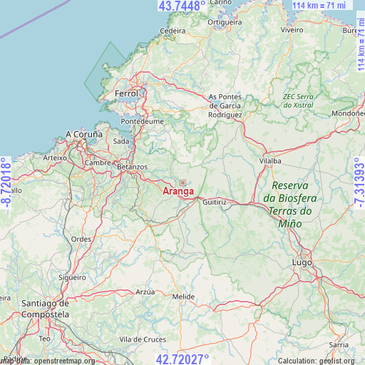
Aranga GPS coordinates[2]
43° 14' 4.884" North, 8° 1' 1.38" West
| Map corner | latitude | longitude |
|---|---|---|
| Upper-left | 43.7448°, | -8.72018° |
| Center: | 43.23469°, | -8.01705° |
| Lower-right: | 42.72027°, | -7.31393° |
| Map W x H: | 113.9×113.9 km | = 70.8×70.8mi |
| max Lat: | 43.74134° ⇑3.3% North |
| Aranga: | 43.23469° |
| min Lat: | ⇓96.7% South 27.64134° |
| min Long | Aranga | max Long |
| -18.00367° | -8.01705° | 4.2899° |
| W 3.6%⇐ | ⇒96.4% E |
Elevation
Elevation of Aranga is 277 m = 909 ft, and this is 321 m = 1053 ft below average elevation for this country.
| Max E: |
1682 m = 5518 ft | 76.6% |
| Avg. | 598 m = 1962 ft | |
| Aranga | 277 m = 909 ft | |
Min E: |
0 m = 0 ft | 23.4% |
See also: Spain elevation on elevation.city.
Geographical zone
Aranga is located in North temperate zone (between Tropic of Cancer and the Arctic Circle). Distance of this Northern Tropic circle is 2201.3 km =1367.8 mi to South.| Distance of | km | miles | from Aranga |
|---|---|---|---|
| North Pole | 5199.8 | 3231 | to North |
| Arctic Circle | 2593.9 | 1611.8 | to North |
| Tropic Cancer | 2201.3 | 1367.8 | to South |
| Equator | 4807.2 | 2987.1 | to South |


Nearby cities:
15 places around Aranga: (largest is in red/bold)
• Abegondo
21.7 km =13.5 mi,  264°
264°
• Bergondo
19.7 km =12.2 mi,  297°
297°
• Betanzos
16.8 km =10.4 mi,  287°
287°
• Cesuras
16.4 km =10.2 mi,  245°
245°
• Coirós
12.2 km =7.6 mi,  277°
277°
• Curtis
16.3 km =10.1 mi,  220°
220°
• Guitiriz
11.4 km =7.1 mi,  121°
121°
• Irixoa
6.5 km =4 mi,  328°
328°
• Mesia
25.2 km =15.7 mi,  233°
233°
• Miño
19.6 km =12.2 mi,  310°
310°
• Monfero
11 km =6.8 mi,  0°
0°
• Paderne
13.9 km =8.6 mi, 294°
• Sada
23.7 km =14.7 mi, 304°
• Sobrado
21.8 km =13.5 mi,  182°
182°
• Vilasantar
20.1 km =12.5 mi,  204°
204°
Sources, notices
• [Note1] Compared only with cities in Spain existing in our database
• [Src1] Map data: © OpenStreetMap contributors (CC-BY-SA)
• [Src2] Other city data from geonames.org with taken over terms of usage.
• [Src3] Geographical zone / Annual Mean Temperature by Robert A. Rohde @ Wikipedia
