Vilasantar geodata
Vilasantar (Galicia) is a seat of a third-order administrative division; located in Spain in Europe/Madrid (GMT+2) time zone. With population of 1,546 people, there are 2425 cities with bigger population in this country. Compared to other cities in Spain, 95% of cities are located further ↓South; 96.6% of cities are located further →East and 66.9% of cities have higher elevation than Vilasantar. Note1


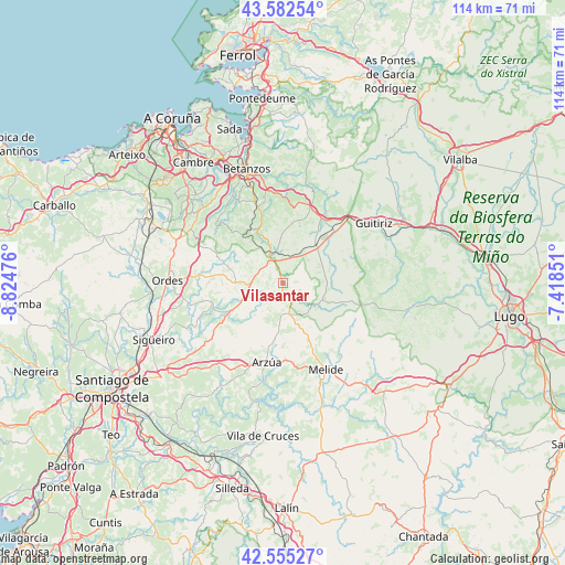
Vilasantar GPS coordinates[2]
43° 4' 15.816" North, 8° 7' 17.868" West
| Map corner | latitude | longitude |
|---|---|---|
| Upper-left | 43.58254°, | -8.82476° |
| Center: | 43.07106°, | -8.12163° |
| Lower-right: | 42.55527°, | -7.41851° |
| Map W x H: | 114.2×114.2 km | = 71×71mi |
| max Lat: | 43.74134° ⇑5% North |
| Vilasantar: | 43.07106° |
| min Lat: | ⇓95% South 27.64134° |
| min Long | Vilasantar | max Long |
| -18.00367° | -8.12163° | 4.2899° |
| W 3.4%⇐ | ⇒96.6% E |
Elevation
Elevation of Vilasantar is 435 m = 1427 ft, and this is 163 m = 535 ft below average elevation for this country.
| Max E: |
1682 m = 5518 ft | 66.9% |
| Avg. | 598 m = 1962 ft | |
| Vilasantar | 435 m = 1427 ft | |
Min E: |
0 m = 0 ft | 33.1% |
See also: Spain elevation on elevation.city.
Geographical zone
Vilasantar is located in North temperate zone (between Tropic of Cancer and the Arctic Circle). Distance of this Northern Tropic circle is 2183.1 km =1356.5 mi to South.| Distance of | km | miles | from Vilasantar |
|---|---|---|---|
| North Pole | 5218 | 3242.3 | to North |
| Arctic Circle | 2612.1 | 1623.1 | to North |
| Tropic Cancer | 2183.1 | 1356.5 | to South |
| Equator | 4789.1 | 2975.8 | to South |


Nearby cities:
15 places around Vilasantar: (largest is in red/bold)
• Abegondo
20.8 km =12.9 mi,  320°
320°
• Aranga
20.1 km =12.5 mi,  24°
24°
• Arzúa
15.5 km =9.6 mi,  188°
188°
• Boimorto
8 km =5 mi, 186°
• Cesuras
13 km =8.1 mi,  330°
330°
• Coirós
20.2 km =12.6 mi,  349°
349°
• Curtis
6.2 km =3.9 mi,  339°
339°
• Frades
14.2 km =8.8 mi,  260°
260°
• Guitiriz
22 km =13.7 mi,  56°
56°
• Melide
19.5 km =12.1 mi,  153°
153°
• Mesia
12.2 km =7.6 mi,  285°
285°
• Ordes
23.3 km =14.5 mi,  271°
271°
• Paderne
24.2 km =15 mi, 349°
• Santiso
22.6 km =14 mi,  166°
166°
• Sobrado
8.4 km =5.2 mi,  115°
115°
Sources, notices
• [Note1] Compared only with cities in Spain existing in our database
• [Src1] Map data: © OpenStreetMap contributors (CC-BY-SA)
• [Src2] Other city data from geonames.org with taken over terms of usage.
• [Src3] Geographical zone / Annual Mean Temperature by Robert A. Rohde @ Wikipedia
