Girona geodata
Girona (Catalonia) is a seat of a second-order administrative division; located in Spain in Europe/Madrid (GMT+2) time zone. With population of 96,188 people, there are 93 cities with bigger population in this country. Compared to other cities in Spain, 73.2% of cities are located further ↓South; 97.7% of cities are located further ←West and 89% of cities have higher elevation than Girona. Note1


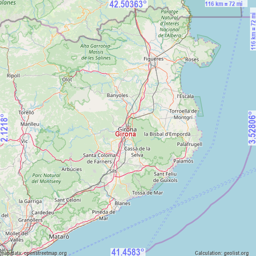
Girona GPS coordinates[2]
41° 58' 59.196" North, 2° 49' 29.748" East
| Map corner | latitude | longitude |
|---|---|---|
| Upper-left | 42.50363°, | 2.1218° |
| Center: | 41.98311°, | 2.82493° |
| Lower-right: | 41.4583°, | 3.52806° |
| Map W x H: | 116.2×116.2 km | = 72.2×72.2mi |
| max Lat: | 43.74134° ⇑26.8% North |
| Girona: | 41.98311° |
| min Lat: | ⇓73.2% South 27.64134° |
| min Long | Girona | max Long |
| -18.00367° | 2.82493° | 4.2899° |
| W 97.7%⇐ | ⇒2.3% E |
Elevation
Elevation of Girona is 81 m = 266 ft, and this is 517 m = 1696 ft below average elevation for this country.
| Max E: |
1682 m = 5518 ft | 89% |
| Avg. | 598 m = 1962 ft | |
| Girona | 81 m = 266 ft | |
Min E: |
0 m = 0 ft | 11% |
See also: Girona elevation on elevation.city.
Geographical zone
Girona is located in North temperate zone (between Tropic of Cancer and the Arctic Circle). Distance of this Northern Tropic circle is 2062.2 km =1281.4 mi to South.| Distance of | km | miles | from Girona |
|---|---|---|---|
| North Pole | 5339 | 3317.5 | to North |
| Arctic Circle | 2733.1 | 1698.3 | to North |
| Tropic Cancer | 2062.2 | 1281.4 | to South |
| Equator | 4668.1 | 2900.6 | to South |


Nearby cities:
15 places around Girona: (largest is in red/bold)
• Aiguaviva
7.2 km =4.5 mi,  226°
226°
• Bescanó
7.3 km =4.5 mi,  254°
254°
• Bordils
9.8 km =6.1 mi,  46°
46°
• Celrà
7.4 km =4.6 mi,  40°
40°
• Fornells de la Selva
5.9 km =3.7 mi,  192°
192°
• Juià
8.4 km =5.2 mi,  63°
63°
• Llambilles
7.2 km =4.5 mi,  162°
162°
• Palol de Revardit
9.5 km =5.9 mi,  347°
347°
• Quart d’Onyar
4.9 km =3 mi, 164°
• Salt
2.8 km =1.7 mi, 251°
• Sant Gregori
7.6 km =4.7 mi,  270°
270°
• Sant Julià de Ramis
5.7 km =3.5 mi,  24°
24°
• Sant Martí Vell
9.7 km =6 mi,  67°
67°
• Sarrià de Ter
3.8 km =2.4 mi,  10°
10°
• Vilablareix
5.1 km =3.2 mi,  236°
236°
Sources, notices
• [Note1] Compared only with cities in Spain existing in our database
• [Src1] Map data: © OpenStreetMap contributors (CC-BY-SA)
• [Src2] Other city data from geonames.org with taken over terms of usage.
• [Src3] Geographical zone / Annual Mean Temperature by Robert A. Rohde @ Wikipedia
