Castronuevo geodata
Castronuevo (Castille and León) is a seat of a third-order administrative division; located in Spain in Europe/Madrid (GMT+2) time zone. With population of 339 people, there are 4351 cities with bigger population in this country. Compared to other cities in Spain, 66.6% of cities are located further ↓South; 79.3% of cities are located further →East and 53% of cities have lower elevation than Castronuevo. Note1
Administrative division(s):
- Level 1: Castille and León
- Level 2: Provincia de Zamora
- Level 3: Castronuevo


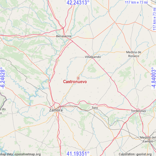
Castronuevo GPS coordinates[2]
41° 43' 13.656" North, 5° 32' 35.34" West
| Map corner | latitude | longitude |
|---|---|---|
| Upper-left | 42.24313°, | -6.24628° |
| Center: | 41.72046°, | -5.54315° |
| Lower-right: | 41.19351°, | -4.84003° |
| Map W x H: | 116.7×116.7 km | = 72.5×72.5mi |
| max Lat: | 43.74134° ⇑33.4% North |
| Castronuevo: | 41.72046° |
| min Lat: | ⇓66.6% South 27.64134° |
| min Long | Castronuevo | max Long |
| -18.00367° | -5.54315° | 4.2899° |
| W 20.7%⇐ | ⇒79.3% E |
Elevation
Elevation of Castronuevo is 691 m = 2267 ft, and this is 93 m = 305 ft above average elevation for this country.
| Max E: |
1682 m = 5518 ft | 47% |
| Castronuevo | 691 m 2267 ft | |
| Avg. | 598 m = 1962 ft | |
Min E: |
0 m = 0 ft | 53% |
See also: Spain elevation on elevation.city.
Geographical zone
Castronuevo is located in North temperate zone (between Tropic of Cancer and the Arctic Circle). Distance of this Northern Tropic circle is 2033 km =1263.2 mi to South.| Distance of | km | miles | from Castronuevo |
|---|---|---|---|
| North Pole | 5368.2 | 3335.6 | to North |
| Arctic Circle | 2762.3 | 1716.4 | to North |
| Tropic Cancer | 2033 | 1263.2 | to South |
| Equator | 4638.9 | 2882.5 | to South |


Nearby cities:
15 places around Castronuevo: (largest is in red/bold)
• Arquillinos
9.5 km =5.9 mi,  262°
262°
• Aspariegos
6.9 km =4.3 mi,  222°
222°
• Belver de los Montes
7.6 km =4.7 mi,  88°
88°
• Bustillo del Oro
8.5 km =5.3 mi,  126°
126°
• Cañizo
6.4 km =4 mi,  32°
32°
• Cerecinos del Carrizal
10 km =6.2 mi,  245°
245°
• Fuentesecas
11.6 km =7.2 mi,  149°
149°
• Malva
8.7 km =5.4 mi, 147°
• Pajares de la Lampreana
12.5 km =7.8 mi,  267°
267°
• Pobladura de Valderaduey
2.3 km =1.4 mi,  177°
177°
• San Martín de Valderaduey
12 km =7.5 mi, 29°
• Villalba de la Lampreana
8.5 km =5.3 mi,  287°
287°
• Villalube
12.3 km =7.6 mi, 180°
• Villarrín de Campos
11.5 km =7.1 mi,  316°
316°
• Villárdiga
12.8 km =8 mi, 30°
Sources, notices
• [Note1] Compared only with cities in Spain existing in our database
• [Src1] Map data: © OpenStreetMap contributors (CC-BY-SA)
• [Src2] Other city data from geonames.org with taken over terms of usage.
• [Src3] Geographical zone / Annual Mean Temperature by Robert A. Rohde @ Wikipedia
